Giáltra geodata
Giáltra (Central Greece) is a populated place; located in Greece in Europe/Athens (GMT+3) time zone. With population of 544 people, there are 1703 cities with bigger population in this country. Compared to other cities in Greece, 56.4% of cities are located further ↑North; 53.9% of cities are located further ←West and 65.2% of cities have lower elevation than Giáltra. Note1
Administrative division(s):
- Level 1: Central Greece
- Level 2: Nomós Evvoías
- Level 3: Dimos Istiaia-Aidipsos


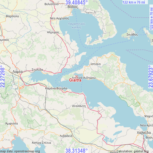
Giáltra GPS coordinates[2]
38° 51' 47.052" North, 22° 58' 33.96" East
| Map corner | latitude | longitude |
|---|---|---|
| Upper-left | 39.40845°, | 22.27298° |
| Center: | 38.86307°, | 22.9761° |
| Lower-right: | 38.31348°, | 23.67923° |
| Map W x H: | 121.7×121.7 km | = 75.6×75.6mi |
| max Lat: | 41.72048° ⇑56.4% North |
| Giáltra: | 38.86307° |
| min Lat: | ⇓43.6% South 34.8346° |
| min Long | Giáltra | max Long |
| 19.40494° | 22.9761° | 29.59361° |
| W 53.9%⇐ | ⇒46.1% E |
Elevation
Elevation of Giáltra is 141 m = 463 ft, and this is 27.9 m = 92 ft below average elevation for this country.
| Max E: |
1439 m = 4721 ft | 34.8% |
| Avg. | 168.9 m = 554 ft | |
| Giáltra | 141 m = 463 ft | |
Min E: |
0 m = 0 ft | 65.2% |
See also: Greece elevation on elevation.city.
Geographical zone
Giáltra is located in North temperate zone (between Tropic of Cancer and the Arctic Circle). Distance of this Northern Tropic circle is 1715.2 km =1065.8 mi to South.| Distance of | km | miles | from Giáltra |
|---|---|---|---|
| North Pole | 5685.9 | 3533.1 | to North |
| Arctic Circle | 3080 | 1913.8 | to North |
| Tropic Cancer | 1715.2 | 1065.8 | to South |
| Equator | 4321.2 | 2685.1 | to South |


Nearby cities:
15 places around Giáltra: (largest is in red/bold)
• Aidipsós
6.4 km =4 mi,  73°
73°
• Akhíllio
15.9 km =9.9 mi,  355°
355°
• Arkítsa
14.2 km =8.8 mi,  159°
159°
• Glífa
10.1 km =6.3 mi, 355°
• Istiaía
18.4 km =11.4 mi,  56°
56°
• Livanátes
18.1 km =11.2 mi, 159°
• Loutrá Aidhipsoú
6.2 km =3.9 mi,  96°
96°
• Néos Pírgos
11.6 km =7.2 mi,  45°
45°
• Oreoí
13.9 km =8.6 mi, 45°
• Paralía Rachón
17.3 km =10.7 mi,  276°
276°
• Pelasgía
15.1 km =9.4 mi,  308°
308°
• Rákhai
17.1 km =10.6 mi, 280°
• Ágios Geórgios Lichádos
8.7 km =5.4 mi,  251°
251°
• Áyios
8.6 km =5.3 mi, 57°
• Áyios Konstandínos
15.7 km =9.8 mi,  220°
220°
Sources, notices
• [Note1] Compared only with cities in Greece existing in our database
• [Src1] Map data: © OpenStreetMap contributors (CC-BY-SA)
• [Src2] Other city data from geonames.org with taken over terms of usage.
• [Src3] Geographical zone / Annual Mean Temperature by Robert A. Rohde @ Wikipedia
