Vlachogiánni geodata
Vlachogiánni (Thessaly) is a populated place; located in Greece in Europe/Athens (GMT+3) time zone. With population of 855 people, there are 1190 cities with bigger population in this country. Compared to other cities in Greece, 63.5% of cities are located further ↓South; 70% of cities are located further →East and 68.7% of cities have lower elevation than Vlachogiánni. Note1


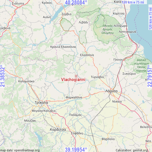
Vlachogiánni GPS coordinates[2]
39° 44' 32.316" North, 22° 5' 18.384" East
| Map corner | latitude | longitude |
|---|---|---|
| Upper-left | 40.28084°, | 21.38532° |
| Center: | 39.74231°, | 22.08844° |
| Lower-right: | 39.19954°, | 22.79157° |
| Map W x H: | 120.2×120.2 km | = 74.7×74.7mi |
| max Lat: | 41.72048° ⇑36.5% North |
| Vlachogiánni: | 39.74231° |
| min Lat: | ⇓63.5% South 34.8346° |
| min Long | Vlachogiánni | max Long |
| 19.40494° | 22.08844° | 29.59361° |
| W 30%⇐ | ⇒70% E |
Elevation
Elevation of Vlachogiánni is 156 m = 512 ft, and this is 12.9 m = 42 ft below average elevation for this country.
| Max E: |
1439 m = 4721 ft | 31.3% |
| Avg. | 168.9 m = 554 ft | |
| Vlachogiánni | 156 m = 512 ft | |
Min E: |
0 m = 0 ft | 68.7% |
See also: Greece elevation on elevation.city.
Geographical zone
Vlachogiánni is located in North temperate zone (between Tropic of Cancer and the Arctic Circle). Distance of this Northern Tropic circle is 1813 km =1126.5 mi to South.| Distance of | km | miles | from Vlachogiánni |
|---|---|---|---|
| North Pole | 5588.1 | 3472.3 | to North |
| Arctic Circle | 2982.2 | 1853.1 | to North |
| Tropic Cancer | 1813 | 1126.5 | to South |
| Equator | 4418.9 | 2745.8 | to South |


Nearby cities:
15 places around Vlachogiánni: (largest is in red/bold)
• Ampelóna
23.7 km =14.7 mi,  89°
89°
• Argyropoúli
20.8 km =12.9 mi,  63°
63°
• Elassóna
19 km =11.8 mi,  26°
26°
• Evangelismós
11 km =6.8 mi,  7°
7°
• Farkadóna
15.9 km =9.9 mi,  186°
186°
• Grizáno
12.7 km =7.9 mi, 194°
• Kríni
15.6 km =9.7 mi,  204°
204°
• Mándra
20.4 km =12.7 mi,  133°
133°
• Oichalía
17.6 km =10.9 mi,  211°
211°
• Petrotó
20.4 km =12.7 mi, 211°
• Petróporo
24.3 km =15.1 mi, 214°
• Tsarítsani
19.5 km =12.1 mi,  37°
37°
• Týrnavos
17.2 km =10.7 mi, 91°
• Verdikoússa
10.5 km =6.5 mi,  294°
294°
• Zárkos
15.2 km =9.4 mi,  168°
168°
Sources, notices
• [Note1] Compared only with cities in Greece existing in our database
• [Src1] Map data: © OpenStreetMap contributors (CC-BY-SA)
• [Src2] Other city data from geonames.org with taken over terms of usage.
• [Src3] Geographical zone / Annual Mean Temperature by Robert A. Rohde @ Wikipedia
