Verdikoússa geodata
Verdikoússa (Thessaly) is a populated place; located in Greece in Europe/Athens (GMT+3) time zone. With population of 1,602 people, there are 623 cities with bigger population in this country. Compared to other cities in Greece, 64.3% of cities are located further ↓South; 72.8% of cities are located further →East and 98.4% of cities have lower elevation than Verdikoússa. Note1


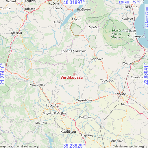
Verdikoússa GPS coordinates[2]
39° 46' 54.3" North, 21° 58' 38.208" East
| Map corner | latitude | longitude |
|---|---|---|
| Upper-left | 40.31997°, | 21.27416° |
| Center: | 39.78175°, | 21.97728° |
| Lower-right: | 39.23929°, | 22.68041° |
| Map W x H: | 120.2×120.2 km | = 74.7×74.7mi |
| max Lat: | 41.72048° ⇑35.7% North |
| Verdikoússa: | 39.78175° |
| min Lat: | ⇓64.3% South 34.8346° |
| min Long | Verdikoússa | max Long |
| 19.40494° | 21.97728° | 29.59361° |
| W 27.2%⇐ | ⇒72.8% E |
Elevation
Elevation of Verdikoússa is 880 m = 2887 ft, and this is 711.1 m = 2333 ft above average elevation for this country.
| Max E: |
1439 m = 4721 ft | 1.6% |
| Verdikoússa | 880 m 2887 ft | |
| Avg. | 168.9 m = 554 ft | |
Min E: |
0 m = 0 ft | 98.4% |
See also: Greece elevation on elevation.city.
Geographical zone
Verdikoússa is located in North temperate zone (between Tropic of Cancer and the Arctic Circle). Distance of this Northern Tropic circle is 1817.4 km =1129.3 mi to South.| Distance of | km | miles | from Verdikoússa |
|---|---|---|---|
| North Pole | 5583.7 | 3469.5 | to North |
| Arctic Circle | 2977.9 | 1850.4 | to North |
| Tropic Cancer | 1817.4 | 1129.3 | to South |
| Equator | 4423.3 | 2748.5 | to South |


Nearby cities:
15 places around Verdikoússa: (largest is in red/bold)
• Ardáni
23.3 km =14.5 mi,  224°
224°
• Deskáti
21.3 km =13.2 mi,  318°
318°
• Elassóna
22 km =13.7 mi,  55°
55°
• Evangelismós
12.6 km =7.8 mi, 59°
• Farkadóna
21.6 km =13.4 mi,  159°
159°
• Grizáno
17.9 km =11.1 mi, 158°
• Kraniá Elassónas
18.8 km =11.7 mi,  358°
358°
• Kríni
18.8 km =11.7 mi,  170°
170°
• Loutró
20.9 km =13 mi,  349°
349°
• Oichalía
19.3 km =12 mi,  179°
179°
• Palaiópyrgos
23.6 km =14.7 mi, 215°
• Petrotó
21.8 km =13.5 mi, 183°
• Plátanos
22.3 km =13.9 mi,  232°
232°
• Vlachogiánni
10.5 km =6.5 mi,  114°
114°
• Zárkos
23 km =14.3 mi,  147°
147°
Sources, notices
• [Note1] Compared only with cities in Greece existing in our database
• [Src1] Map data: © OpenStreetMap contributors (CC-BY-SA)
• [Src2] Other city data from geonames.org with taken over terms of usage.
• [Src3] Geographical zone / Annual Mean Temperature by Robert A. Rohde @ Wikipedia
