Loutró geodata
Loutró (Thessaly) is a populated place; located in Greece in Europe/Athens (GMT+3) time zone. With population of 841 people, there are 1208 cities with bigger population in this country. Compared to other cities in Greece, 66.3% of cities are located further ↓South; 73.6% of cities are located further →East and 95.9% of cities have lower elevation than Loutró. Note1


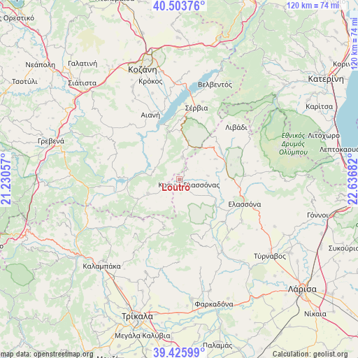
Loutró GPS coordinates[2]
39° 58' 1.2" North, 21° 56' 1.284" East
| Map corner | latitude | longitude |
|---|---|---|
| Upper-left | 40.50376°, | 21.23057° |
| Center: | 39.967°, | 21.93369° |
| Lower-right: | 39.42599°, | 22.63682° |
| Map W x H: | 119.8×119.8 km | = 74.4×74.4mi |
| max Lat: | 41.72048° ⇑33.7% North |
| Loutró: | 39.967° |
| min Lat: | ⇓66.3% South 34.8346° |
| min Long | Loutró | max Long |
| 19.40494° | 21.93369° | 29.59361° |
| W 26.4%⇐ | ⇒73.6% E |
Elevation
Elevation of Loutró is 706 m = 2316 ft, and this is 537.1 m = 1762 ft above average elevation for this country.
| Max E: |
1439 m = 4721 ft | 4.1% |
| Loutró | 706 m 2316 ft | |
| Avg. | 168.9 m = 554 ft | |
Min E: |
0 m = 0 ft | 95.9% |
See also: Greece elevation on elevation.city.
Geographical zone
Loutró is located in North temperate zone (between Tropic of Cancer and the Arctic Circle). Distance of this Northern Tropic circle is 1838 km =1142.1 mi to South.| Distance of | km | miles | from Loutró |
|---|---|---|---|
| North Pole | 5563.1 | 3456.7 | to North |
| Arctic Circle | 2957.3 | 1837.6 | to North |
| Tropic Cancer | 1838 | 1142.1 | to South |
| Equator | 4443.9 | 2761.3 | to South |


Nearby cities:
15 places around Loutró: (largest is in red/bold)
• Aianí
23.9 km =14.9 mi,  336°
336°
• Deskáti
11.5 km =7.1 mi,  245°
245°
• Dímitra
23.3 km =14.5 mi,  264°
264°
• Elassóna
23.2 km =14.4 mi,  110°
110°
• Eláti
9.5 km =5.9 mi,  278°
278°
• Evangelismós
20.3 km =12.6 mi,  134°
134°
• Kastaniá
24.3 km =15.1 mi,  18°
18°
• Kraniá Elassónas
3.6 km =2.2 mi,  119°
119°
• Livaderó
7.6 km =4.7 mi,  5°
5°
• Livádi
26 km =16.2 mi,  47°
47°
• Nea Lava
25.8 km =16 mi, 15°
• Sarantáporo
15.1 km =9.4 mi,  42°
42°
• Sérvia
24.2 km =15 mi, 12°
• Verdikoússa
20.9 km =13 mi,  169°
169°
• Ázoros
12.9 km =8 mi,  73°
73°
Sources, notices
• [Note1] Compared only with cities in Greece existing in our database
• [Src1] Map data: © OpenStreetMap contributors (CC-BY-SA)
• [Src2] Other city data from geonames.org with taken over terms of usage.
• [Src3] Geographical zone / Annual Mean Temperature by Robert A. Rohde @ Wikipedia
