Deskáti geodata
Deskáti (West Macedonia) is a seat of a third-order administrative division; located in Greece in Europe/Athens (GMT+3) time zone. With population of 3,856 people, there are 286 cities with bigger population in this country. Compared to other cities in Greece, 65.8% of cities are located further ↓South; 76.2% of cities are located further →East and 98.2% of cities have lower elevation than Deskáti. Note1


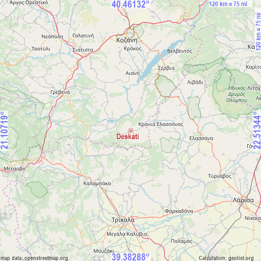
Deskáti GPS coordinates[2]
39° 55' 27.192" North, 21° 48' 37.116" East
| Map corner | latitude | longitude |
|---|---|---|
| Upper-left | 40.46132°, | 21.10719° |
| Center: | 39.92422°, | 21.81031° |
| Lower-right: | 39.38288°, | 22.51344° |
| Map W x H: | 119.9×119.9 km | = 74.5×74.5mi |
| max Lat: | 41.72048° ⇑34.2% North |
| Deskáti: | 39.92422° |
| min Lat: | ⇓65.8% South 34.8346° |
| min Long | Deskáti | max Long |
| 19.40494° | 21.81031° | 29.59361° |
| W 23.8%⇐ | ⇒76.2% E |
Elevation
Elevation of Deskáti is 862 m = 2828 ft, and this is 693.1 m = 2274 ft above average elevation for this country.
| Max E: |
1439 m = 4721 ft | 1.8% |
| Deskáti | 862 m 2828 ft | |
| Avg. | 168.9 m = 554 ft | |
Min E: |
0 m = 0 ft | 98.2% |
See also: Greece elevation on elevation.city.
Geographical zone
Deskáti is located in North temperate zone (between Tropic of Cancer and the Arctic Circle). Distance of this Northern Tropic circle is 1833.2 km =1139.1 mi to South.| Distance of | km | miles | from Deskáti |
|---|---|---|---|
| North Pole | 5567.9 | 3459.7 | to North |
| Arctic Circle | 2962 | 1840.5 | to North |
| Tropic Cancer | 1833.2 | 1139.1 | to South |
| Equator | 4439.2 | 2758.4 | to South |


Nearby cities:
15 places around Deskáti: (largest is in red/bold)
• Agiófyllo
22.3 km =13.9 mi,  252°
252°
• Aianí
26.7 km =16.6 mi,  1°
1°
• Asprokklisiá
15 km =9.3 mi,  236°
236°
• Dímitra
12.9 km =8 mi,  281°
281°
• Eláti
6.2 km =3.9 mi,  9°
9°
• Evangelismós
26.8 km =16.7 mi,  110°
110°
• Karperó
16.5 km =10.3 mi, 278°
• Kastráki
28.3 km =17.6 mi,  215°
215°
• Kraniá Elassónas
14 km =8.7 mi,  77°
77°
• Livaderó
16.7 km =10.4 mi,  42°
42°
• Loutró
11.5 km =7.1 mi,  65°
65°
• Sarantáporo
26.1 km =16.2 mi,  52°
52°
• Verdikoússa
21.3 km =13.2 mi,  138°
138°
• Ávra
25.8 km =16 mi,  203°
203°
• Ázoros
24.4 km =15.2 mi, 69°
Sources, notices
• [Note1] Compared only with cities in Greece existing in our database
• [Src1] Map data: © OpenStreetMap contributors (CC-BY-SA)
• [Src2] Other city data from geonames.org with taken over terms of usage.
• [Src3] Geographical zone / Annual Mean Temperature by Robert A. Rohde @ Wikipedia
