Tsoukaládhes geodata
Tsoukaládhes (Ionian Islands) is a populated place; located in Greece in Europe/Athens (GMT+3) time zone. With population of 514 people, there are 1781 cities with bigger population in this country. Compared to other cities in Greece, 57.1% of cities are located further ↑North; 95.7% of cities are located further →East and 77% of cities have lower elevation than Tsoukaládhes. Note1


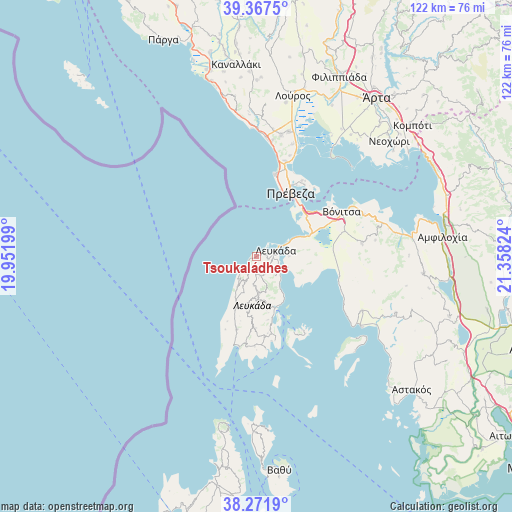
Tsoukaládhes GPS coordinates[2]
38° 49' 18.516" North, 20° 39' 18.396" East
| Map corner | latitude | longitude |
|---|---|---|
| Upper-left | 39.3675°, | 19.95199° |
| Center: | 38.82181°, | 20.65511° |
| Lower-right: | 38.2719°, | 21.35824° |
| Map W x H: | 121.8×121.8 km | = 75.7×75.7mi |
| max Lat: | 41.72048° ⇑57.1% North |
| Tsoukaládhes: | 38.82181° |
| min Lat: | ⇓42.9% South 34.8346° |
| min Long | Tsoukaládhes | max Long |
| 19.40494° | 20.65511° | 29.59361° |
| W 4.3%⇐ | ⇒95.7% E |
Elevation
Elevation of Tsoukaládhes is 233 m = 764 ft, and this is 64.1 m = 210 ft above average elevation for this country.
| Max E: |
1439 m = 4721 ft | 23% |
| Tsoukaládhes | 233 m 764 ft | |
| Avg. | 168.9 m = 554 ft | |
Min E: |
0 m = 0 ft | 77% |
See also: Greece elevation on elevation.city.
Geographical zone
Tsoukaládhes is located in North temperate zone (between Tropic of Cancer and the Arctic Circle). Distance of this Northern Tropic circle is 1710.7 km =1063 mi to South.| Distance of | km | miles | from Tsoukaládhes |
|---|---|---|---|
| North Pole | 5690.5 | 3535.9 | to North |
| Arctic Circle | 3084.6 | 1916.7 | to North |
| Tropic Cancer | 1710.7 | 1063 | to South |
| Equator | 4316.6 | 2682.2 | to South |


Nearby cities:
15 places around Tsoukaládhes: (largest is in red/bold)
• Apólpaina
2.8 km =1.7 mi,  104°
104°
• Kariótai
5.8 km =3.6 mi,  116°
116°
• Karyá
7 km =4.3 mi,  184°
184°
• Lazaráta
5 km =3.1 mi,  167°
167°
• Lefkáda
4.4 km =2.7 mi,  77°
77°
• Ligia
6.8 km =4.2 mi, 124°
• Monastiráki
25.3 km =15.7 mi, 82°
• Mýtikas
20 km =12.4 mi,  12°
12°
• Nidhríon
13.4 km =8.3 mi,  157°
157°
• Nikiána
8.8 km =5.5 mi,  141°
141°
• Plagiá
7.8 km =4.8 mi,  108°
108°
• Préveza
17.1 km =10.6 mi,  28°
28°
• Pálairos
20.1 km =12.5 mi, 102°
• Vónitsa
22.6 km =14 mi,  62°
62°
• Ágios Nikólaos
13.9 km =8.6 mi,  67°
67°
Sources, notices
• [Note1] Compared only with cities in Greece existing in our database
• [Src1] Map data: © OpenStreetMap contributors (CC-BY-SA)
• [Src2] Other city data from geonames.org with taken over terms of usage.
• [Src3] Geographical zone / Annual Mean Temperature by Robert A. Rohde @ Wikipedia
