Trípoli geodata
Trípoli (Peloponnese) is a seat of a first-order administrative division; located in Greece in Europe/Athens (GMT+3) time zone. With population of 26,561 people, there are 71 cities with bigger population in this country. Compared to other cities in Greece, 85.8% of cities are located further ↑North; 63.3% of cities are located further →East and 94.8% of cities have lower elevation than Trípoli. Note1


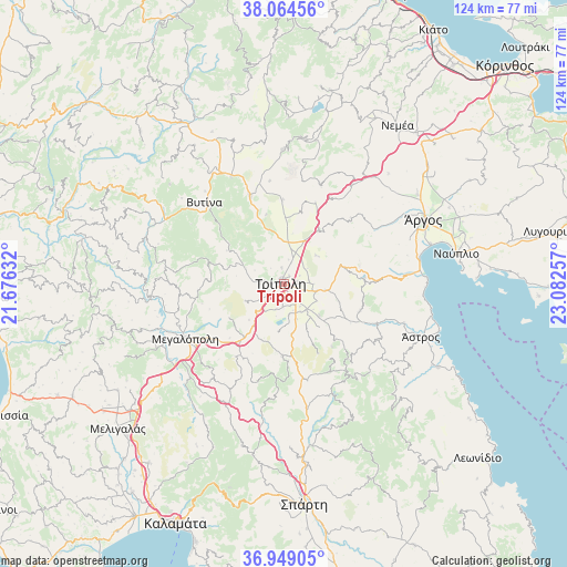
Trípoli GPS coordinates[2]
37° 30' 32.004" North, 22° 22' 45.984" East
| Map corner | latitude | longitude |
|---|---|---|
| Upper-left | 38.06456°, | 21.67632° |
| Center: | 37.50889°, | 22.37944° |
| Lower-right: | 36.94905°, | 23.08257° |
| Map W x H: | 124×124 km | = 77.1×77.1mi |
| max Lat: | 41.72048° ⇑85.8% North |
| Trípoli: | 37.50889° |
| min Lat: | ⇓14.2% South 34.8346° |
| min Long | Trípoli | max Long |
| 19.40494° | 22.37944° | 29.59361° |
| W 36.7%⇐ | ⇒63.3% E |
Elevation
Elevation of Trípoli is 660 m = 2165 ft, and this is 491.1 m = 1611 ft above average elevation for this country.
| Max E: |
1439 m = 4721 ft | 5.2% |
| Trípoli | 660 m 2165 ft | |
| Avg. | 168.9 m = 554 ft | |
Min E: |
0 m = 0 ft | 94.8% |
See also: Greece elevation on elevation.city.
Geographical zone
Trípoli is located in North temperate zone (between Tropic of Cancer and the Arctic Circle). Distance of this Northern Tropic circle is 1564.7 km =972.3 mi to South.| Distance of | km | miles | from Trípoli |
|---|---|---|---|
| North Pole | 5836.5 | 3626.6 | to North |
| Arctic Circle | 3230.6 | 2007.4 | to North |
| Tropic Cancer | 1564.7 | 972.3 | to South |
| Equator | 4170.6 | 2591.5 | to South |


Nearby cities:
15 places around Trípoli: (largest is in red/bold)
• Dimitsána
31.4 km =19.5 mi,  287°
287°
• Kandíla
29.3 km =18.2 mi,  359°
359°
• Karyés
26.5 km =16.5 mi,  156°
156°
• Kefalári
29.2 km =18.1 mi,  70°
70°
• Kivéri
30.9 km =19.2 mi,  86°
86°
• Koutsopódi
35.3 km =21.9 mi,  56°
56°
• Levídion
20.7 km =12.9 mi,  339°
339°
• Megalópoli
24.1 km =15 mi,  240°
240°
• Mýloi
30.1 km =18.7 mi,  80°
80°
• Néa Kíos
33.3 km =20.7 mi, 74°
• Vlachokerasiá
15.7 km =9.8 mi,  180°
180°
• Vytína
24.9 km =15.5 mi,  316°
316°
• Ágios Pétros
25 km =15.5 mi,  143°
143°
• Árgos
34.1 km =21.2 mi, 66°
• Ástros
32.3 km =20.1 mi,  111°
111°
Sources, notices
• [Note1] Compared only with cities in Greece existing in our database
• [Src1] Map data: © OpenStreetMap contributors (CC-BY-SA)
• [Src2] Other city data from geonames.org with taken over terms of usage.
• [Src3] Geographical zone / Annual Mean Temperature by Robert A. Rohde @ Wikipedia
