Dimitsána geodata
Dimitsána (Peloponnese) is a seat of a third-order administrative division; located in Greece in Europe/Athens (GMT+3) time zone. With population of 739 people, there are 1350 cities with bigger population in this country. Compared to other cities in Greece, 84.9% of cities are located further ↑North; 71.3% of cities are located further →East and 99.4% of cities have lower elevation than Dimitsána. Note1


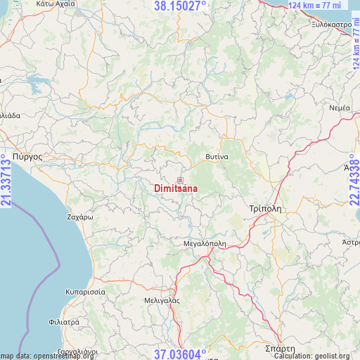
Dimitsána GPS coordinates[2]
37° 35' 42.864" North, 22° 2' 24.9" East
| Map corner | latitude | longitude |
|---|---|---|
| Upper-left | 38.15027°, | 21.33713° |
| Center: | 37.59524°, | 22.04025° |
| Lower-right: | 37.03604°, | 22.74338° |
| Map W x H: | 123.9×123.9 km | = 77×77mi |
| max Lat: | 41.72048° ⇑84.9% North |
| Dimitsána: | 37.59524° |
| min Lat: | ⇓15.1% South 34.8346° |
| min Long | Dimitsána | max Long |
| 19.40494° | 22.04025° | 29.59361° |
| W 28.7%⇐ | ⇒71.3% E |
Elevation
Elevation of Dimitsána is 961 m = 3153 ft, and this is 792.1 m = 2599 ft above average elevation for this country.
| Max E: |
1439 m = 4721 ft | 0.59999999999999% |
| Dimitsána | 961 m 3153 ft | |
| Avg. | 168.9 m = 554 ft | |
Min E: |
0 m = 0 ft | 99.4% |
See also: Greece elevation on elevation.city.
Geographical zone
Dimitsána is located in North temperate zone (between Tropic of Cancer and the Arctic Circle). Distance of this Northern Tropic circle is 1574.3 km =978.2 mi to South.| Distance of | km | miles | from Dimitsána |
|---|---|---|---|
| North Pole | 5826.9 | 3620.7 | to North |
| Arctic Circle | 3221 | 2001.4 | to North |
| Tropic Cancer | 1574.3 | 978.2 | to South |
| Equator | 4180.2 | 2597.5 | to South |


Nearby cities:
15 places around Dimitsána: (largest is in red/bold)
• Andrítsaina
17.2 km =10.7 mi,  223°
223°
• Archaía Olympía
36.9 km =22.9 mi,  279°
279°
• Kallithéa
20 km =12.4 mi,  255°
255°
• Kandíla
35.7 km =22.2 mi,  56°
56°
• Kréstena
37 km =23 mi,  269°
269°
• Langádhia
9.7 km =6 mi,  354°
354°
• Levídion
24.5 km =15.2 mi,  66°
66°
• Lálas
30.8 km =19.1 mi,  294°
294°
• Makrísia
38.4 km =23.9 mi, 272°
• Megalópoli
23.4 km =14.5 mi,  157°
157°
• Plátanos
38.6 km =24 mi, 281°
• Trípoli
31.4 km =19.5 mi,  107°
107°
• Vrína
35.5 km =22.1 mi, 265°
• Vytína
15.1 km =9.4 mi, 56°
• Zacháro
36.6 km =22.7 mi,  250°
250°
Sources, notices
• [Note1] Compared only with cities in Greece existing in our database
• [Src1] Map data: © OpenStreetMap contributors (CC-BY-SA)
• [Src2] Other city data from geonames.org with taken over terms of usage.
• [Src3] Geographical zone / Annual Mean Temperature by Robert A. Rohde @ Wikipedia
