Kandíla geodata
Kandíla (Peloponnese) is a populated place; located in Greece in Europe/Athens (GMT+3) time zone. With population of 690 people, there are 1427 cities with bigger population in this country. Compared to other cities in Greece, 80.8% of cities are located further ↑North; 63.4% of cities are located further →East and 96.9% of cities have lower elevation than Kandíla. Note1


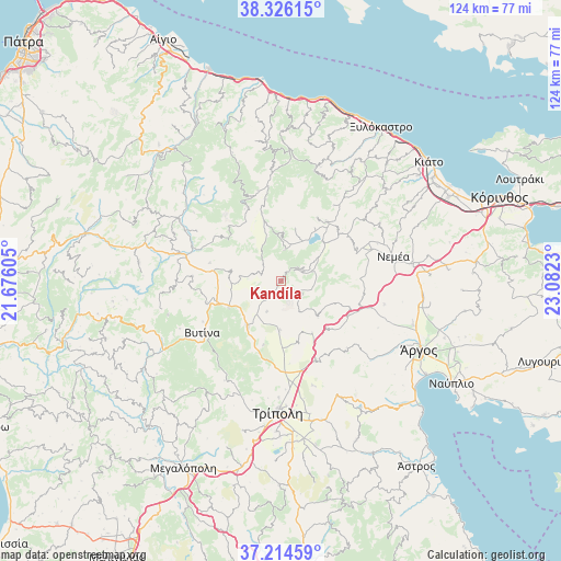
Kandíla GPS coordinates[2]
37° 46' 20.856" North, 22° 22' 45.012" East
| Map corner | latitude | longitude |
|---|---|---|
| Upper-left | 38.32615°, | 21.67605° |
| Center: | 37.77246°, | 22.37917° |
| Lower-right: | 37.21459°, | 23.0823° |
| Map W x H: | 123.6×123.6 km | = 76.8×76.8mi |
| max Lat: | 41.72048° ⇑80.8% North |
| Kandíla: | 37.77246° |
| min Lat: | ⇓19.2% South 34.8346° |
| min Long | Kandíla | max Long |
| 19.40494° | 22.37917° | 29.59361° |
| W 36.6%⇐ | ⇒63.4% E |
Elevation
Elevation of Kandíla is 769 m = 2523 ft, and this is 600.1 m = 1969 ft above average elevation for this country.
| Max E: |
1439 m = 4721 ft | 3.1% |
| Kandíla | 769 m 2523 ft | |
| Avg. | 168.9 m = 554 ft | |
Min E: |
0 m = 0 ft | 96.9% |
See also: Greece elevation on elevation.city.
Geographical zone
Kandíla is located in North temperate zone (between Tropic of Cancer and the Arctic Circle). Distance of this Northern Tropic circle is 1594 km =990.5 mi to South.| Distance of | km | miles | from Kandíla |
|---|---|---|---|
| North Pole | 5807.2 | 3608.4 | to North |
| Arctic Circle | 3201.3 | 1989.2 | to North |
| Tropic Cancer | 1594 | 990.5 | to South |
| Equator | 4199.9 | 2609.7 | to South |


Nearby cities:
15 places around Kandíla: (largest is in red/bold)
• ArchaÍes Kleonés
33.1 km =20.6 mi,  80°
80°
• Dimitsána
35.7 km =22.2 mi,  236°
236°
• Fíkhtion
30.9 km =19.2 mi,  100°
100°
• Kefalári
33.6 km =20.9 mi,  125°
125°
• Koutsopódi
31 km =19.3 mi,  108°
108°
• Krionérion
31 km =19.3 mi,  46°
46°
• Langádhia
32.3 km =20.1 mi,  251°
251°
• Levídion
12.4 km =7.7 mi,  216°
216°
• Neméa
25.3 km =15.7 mi, 77°
• Stimánga
32.1 km =19.9 mi,  61°
61°
• Trípoli
29.3 km =18.2 mi,  179°
179°
• Vytína
20.6 km =12.8 mi, 236°
• Árgos
34.8 km =21.6 mi,  116°
116°
• Áyios Vasílios
36.8 km =22.9 mi,  85°
85°
• Ínachos
34.8 km =21.6 mi, 110°
Sources, notices
• [Note1] Compared only with cities in Greece existing in our database
• [Src1] Map data: © OpenStreetMap contributors (CC-BY-SA)
• [Src2] Other city data from geonames.org with taken over terms of usage.
• [Src3] Geographical zone / Annual Mean Temperature by Robert A. Rohde @ Wikipedia
