Rizovoúni geodata
Rizovoúni (Epirus) is a populated place; located in Greece in Europe/Athens (GMT+3) time zone. With population of 808 people, there are 1265 cities with bigger population in this country. Compared to other cities in Greece, 50.6% of cities are located further ↓South; 93.6% of cities are located further →East and 63.9% of cities have lower elevation than Rizovoúni. Note1


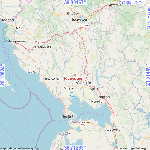
Rizovoúni GPS coordinates[2]
39° 15' 33.696" North, 20° 48' 40.896" East
| Map corner | latitude | longitude |
|---|---|---|
| Upper-left | 39.80167°, | 20.10824° |
| Center: | 39.25936°, | 20.81136° |
| Lower-right: | 38.71283°, | 21.51449° |
| Map W x H: | 121.1×121.1 km | = 75.2×75.2mi |
| max Lat: | 41.72048° ⇑49.4% North |
| Rizovoúni: | 39.25936° |
| min Lat: | ⇓50.6% South 34.8346° |
| min Long | Rizovoúni | max Long |
| 19.40494° | 20.81136° | 29.59361° |
| W 6.4%⇐ | ⇒93.6% E |
Elevation
Elevation of Rizovoúni is 135 m = 443 ft, and this is 33.9 m = 111 ft below average elevation for this country.
| Max E: |
1439 m = 4721 ft | 36.1% |
| Avg. | 168.9 m = 554 ft | |
| Rizovoúni | 135 m = 443 ft | |
Min E: |
0 m = 0 ft | 63.9% |
See also: Greece elevation on elevation.city.
Geographical zone
Rizovoúni is located in North temperate zone (between Tropic of Cancer and the Arctic Circle). Distance of this Northern Tropic circle is 1759.3 km =1093.2 mi to South.| Distance of | km | miles | from Rizovoúni |
|---|---|---|---|
| North Pole | 5641.8 | 3505.7 | to North |
| Arctic Circle | 3035.9 | 1886.4 | to North |
| Tropic Cancer | 1759.3 | 1093.2 | to South |
| Equator | 4365.2 | 2712.4 | to South |


Nearby cities:
15 places around Rizovoúni: (largest is in red/bold)
• Ammótopos
11.4 km =7.1 mi,  83°
83°
• Filippiáda
8.6 km =5.3 mi,  134°
134°
• Gymnótopos
8.7 km =5.4 mi,  67°
67°
• Kampí
8.9 km =5.5 mi,  121°
121°
• Kranéa
5.7 km =3.5 mi,  255°
255°
• Loúros
11.4 km =7.1 mi,  204°
204°
• Néa Kerasoúnta
12 km =7.5 mi,  160°
160°
• Néos Oropós
13.7 km =8.5 mi,  208°
208°
• Oropós
13.3 km =8.3 mi,  217°
217°
• Pappadátes
6.3 km =3.9 mi,  345°
345°
• Pétra
11.4 km =7.1 mi,  176°
176°
• Stefáni
8.9 km =5.5 mi,  191°
191°
• Thesprotikó
2.4 km =1.5 mi,  247°
247°
• Ágios Geórgios
3.8 km =2.4 mi, 77°
• Ágios Spyrídon
13.6 km =8.5 mi, 160°
Sources, notices
• [Note1] Compared only with cities in Greece existing in our database
• [Src1] Map data: © OpenStreetMap contributors (CC-BY-SA)
• [Src2] Other city data from geonames.org with taken over terms of usage.
• [Src3] Geographical zone / Annual Mean Temperature by Robert A. Rohde @ Wikipedia
