Ammótopos geodata
Ammótopos (Epirus) is a populated place; located in Greece in Europe/Athens (GMT+3) time zone. With population of 618 people, there are 1551 cities with bigger population in this country. Compared to other cities in Greece, 50.8% of cities are located further ↓South; 90.6% of cities are located further →East and 79.2% of cities have lower elevation than Ammótopos. Note1


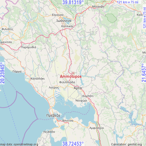
Ammótopos GPS coordinates[2]
39° 16' 15.492" North, 20° 56' 33.252" East
| Map corner | latitude | longitude |
|---|---|---|
| Upper-left | 39.81319°, | 20.23945° |
| Center: | 39.27097°, | 20.94257° |
| Lower-right: | 38.72453°, | 21.6457° |
| Map W x H: | 121×121 km | = 75.2×75.2mi |
| max Lat: | 41.72048° ⇑49.2% North |
| Ammótopos: | 39.27097° |
| min Lat: | ⇓50.8% South 34.8346° |
| min Long | Ammótopos | max Long |
| 19.40494° | 20.94257° | 29.59361° |
| W 9.4%⇐ | ⇒90.6% E |
Elevation
Elevation of Ammótopos is 268 m = 879 ft, and this is 99.1 m = 325 ft above average elevation for this country.
| Max E: |
1439 m = 4721 ft | 20.8% |
| Ammótopos | 268 m 879 ft | |
| Avg. | 168.9 m = 554 ft | |
Min E: |
0 m = 0 ft | 79.2% |
See also: Greece elevation on elevation.city.
Geographical zone
Ammótopos is located in North temperate zone (between Tropic of Cancer and the Arctic Circle). Distance of this Northern Tropic circle is 1760.6 km =1094 mi to South.| Distance of | km | miles | from Ammótopos |
|---|---|---|---|
| North Pole | 5640.5 | 3504.8 | to North |
| Arctic Circle | 3034.7 | 1885.7 | to North |
| Tropic Cancer | 1760.6 | 1094 | to South |
| Equator | 4366.5 | 2713.2 | to South |


Nearby cities:
15 places around Ammótopos: (largest is in red/bold)
• Chalkiádes
12.4 km =7.7 mi,  183°
183°
• Eleoúsa
13.2 km =8.2 mi,  172°
172°
• Filippiáda
9 km =5.6 mi,  215°
215°
• Grammenítsa
10.1 km =6.3 mi,  161°
161°
• Gymnótopos
3.9 km =2.4 mi,  302°
302°
• Kalamiá
11.8 km =7.3 mi, 184°
• Kampí
7 km =4.3 mi,  211°
211°
• Néa Kerasoúnta
14.6 km =9.1 mi, 210°
• Pappadátes
13.7 km =8.5 mi,  290°
290°
• Péta
14.1 km =8.8 mi,  145°
145°
• Rizovoúni
11.4 km =7.1 mi,  263°
263°
• Rókka
11.6 km =7.2 mi, 179°
• Thesprotikó
13.7 km =8.5 mi, 260°
• Ágios Geórgios
7.6 km =4.7 mi,  266°
266°
• Árta
12.9 km =8 mi, 163°
Sources, notices
• [Note1] Compared only with cities in Greece existing in our database
• [Src1] Map data: © OpenStreetMap contributors (CC-BY-SA)
• [Src2] Other city data from geonames.org with taken over terms of usage.
• [Src3] Geographical zone / Annual Mean Temperature by Robert A. Rohde @ Wikipedia
