Kampí geodata
Kampí (Epirus) is a populated place; located in Greece in Europe/Athens (GMT+3) time zone. With population of 928 people, there are 1093 cities with bigger population in this country. Compared to other cities in Greece, 50.2% of cities are located further ↑North; 91.2% of cities are located further →East and 76.1% of cities have higher elevation than Kampí. Note1


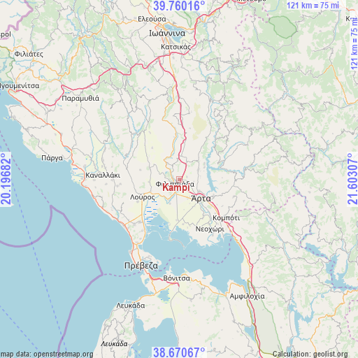
Kampí GPS coordinates[2]
39° 13' 3.108" North, 20° 53' 59.784" East
| Map corner | latitude | longitude |
|---|---|---|
| Upper-left | 39.76016°, | 20.19682° |
| Center: | 39.21753°, | 20.89994° |
| Lower-right: | 38.67067°, | 21.60307° |
| Map W x H: | 121.1×121.1 km | = 75.2×75.2mi |
| max Lat: | 41.72048° ⇑50.2% North |
| Kampí: | 39.21753° |
| min Lat: | ⇓49.8% South 34.8346° |
| min Long | Kampí | max Long |
| 19.40494° | 20.89994° | 29.59361° |
| W 8.8%⇐ | ⇒91.2% E |
Elevation
Elevation of Kampí is 22 m = 72 ft, and this is 146.9 m = 482 ft below average elevation for this country.
| Max E: |
1439 m = 4721 ft | 76.1% |
| Avg. | 168.9 m = 554 ft | |
| Kampí | 22 m = 72 ft | |
Min E: |
0 m = 0 ft | 23.9% |
See also: Greece elevation on elevation.city.
Geographical zone
Kampí is located in North temperate zone (between Tropic of Cancer and the Arctic Circle). Distance of this Northern Tropic circle is 1754.7 km =1090.3 mi to South.| Distance of | km | miles | from Kampí |
|---|---|---|---|
| North Pole | 5646.5 | 3508.6 | to North |
| Arctic Circle | 3040.6 | 1889.3 | to North |
| Tropic Cancer | 1754.7 | 1090.3 | to South |
| Equator | 4360.6 | 2709.6 | to South |


Nearby cities:
15 places around Kampí: (largest is in red/bold)
• Ammótopos
7 km =4.3 mi,  31°
31°
• Chalkiádes
7 km =4.3 mi,  156°
156°
• Eleoúsa
9 km =5.6 mi,  143°
143°
• Filippiáda
2.1 km =1.3 mi,  226°
226°
• Grammenítsa
7.8 km =4.8 mi,  118°
118°
• Gymnótopos
8 km =5 mi,  2°
2°
• Kalamiá
6.4 km =4 mi,  154°
154°
• Kalóvatos
10.2 km =6.3 mi,  171°
171°
• Néa Kerasoúnta
7.7 km =4.8 mi,  208°
208°
• Pétra
9.7 km =6 mi, 226°
• Rizovoúni
8.9 km =5.5 mi,  301°
301°
• Rókka
6.8 km =4.2 mi, 146°
• Ágios Geórgios
6.8 km =4.2 mi,  324°
324°
• Ágios Spyrídon
8.8 km =5.5 mi,  201°
201°
• Árta
9.8 km =6.1 mi,  130°
130°
Sources, notices
• [Note1] Compared only with cities in Greece existing in our database
• [Src1] Map data: © OpenStreetMap contributors (CC-BY-SA)
• [Src2] Other city data from geonames.org with taken over terms of usage.
• [Src3] Geographical zone / Annual Mean Temperature by Robert A. Rohde @ Wikipedia
