Parapótamos geodata
Parapótamos (Epirus) is a populated place; located in Greece in Europe/Athens (GMT+3) time zone. With population of 1,126 people, there are 896 cities with bigger population in this country. Compared to other cities in Greece, 57.8% of cities are located further ↓South; 96.9% of cities are located further →East and 62.7% of cities have lower elevation than Parapótamos. Note1


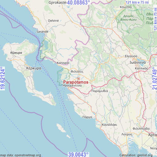
Parapótamos GPS coordinates[2]
39° 32' 54.888" North, 20° 19' 27.696" East
| Map corner | latitude | longitude |
|---|---|---|
| Upper-left | 40.08863°, | 19.62124° |
| Center: | 39.54858°, | 20.32436° |
| Lower-right: | 39.0043°, | 21.02749° |
| Map W x H: | 120.6×120.6 km | = 74.9×74.9mi |
| max Lat: | 41.72048° ⇑42.2% North |
| Parapótamos: | 39.54858° |
| min Lat: | ⇓57.8% South 34.8346° |
| min Long | Parapótamos | max Long |
| 19.40494° | 20.32436° | 29.59361° |
| W 3.1%⇐ | ⇒96.9% E |
Elevation
Elevation of Parapótamos is 129 m = 423 ft, and this is 39.9 m = 131 ft below average elevation for this country.
| Max E: |
1439 m = 4721 ft | 37.3% |
| Avg. | 168.9 m = 554 ft | |
| Parapótamos | 129 m = 423 ft | |
Min E: |
0 m = 0 ft | 62.7% |
See also: Greece elevation on elevation.city.
Geographical zone
Parapótamos is located in North temperate zone (between Tropic of Cancer and the Arctic Circle). Distance of this Northern Tropic circle is 1791.5 km =1113.2 mi to South.| Distance of | km | miles | from Parapótamos |
|---|---|---|---|
| North Pole | 5609.7 | 3485.7 | to North |
| Arctic Circle | 3003.8 | 1866.5 | to North |
| Tropic Cancer | 1791.5 | 1113.2 | to South |
| Equator | 4397.4 | 2732.4 | to South |


Nearby cities:
15 places around Parapótamos: (largest is in red/bold)
• Agiá
26.4 km =16.4 mi,  173°
173°
• Filiátes
5.9 km =3.7 mi,  349°
349°
• Graikochóri
7 km =4.3 mi,  216°
216°
• Igoumenítsa
7 km =4.3 mi, 224°
• Kastrí
4.3 km =2.7 mi,  275°
275°
• Kávos
25.6 km =15.9 mi,  226°
226°
• Lefkímmi
25.8 km =16 mi,  237°
237°
• Margaríti
23.3 km =14.5 mi,  155°
155°
• Mazarakiá
15.1 km =9.4 mi, 163°
• Néa Seléfkeia
6.5 km =4 mi,  245°
245°
• Paramythiá
18.2 km =11.3 mi,  118°
118°
• Platariá
11.6 km =7.2 mi,  200°
200°
• Pérdika
20 km =12.4 mi,  184°
184°
• Sagiáda
13.9 km =8.6 mi,  306°
306°
• Sývota
17 km =10.6 mi, 202°
Sources, notices
• [Note1] Compared only with cities in Greece existing in our database
• [Src1] Map data: © OpenStreetMap contributors (CC-BY-SA)
• [Src2] Other city data from geonames.org with taken over terms of usage.
• [Src3] Geographical zone / Annual Mean Temperature by Robert A. Rohde @ Wikipedia
