Igoumenítsa geodata
Igoumenítsa (Epirus) is a seat of a second-order administrative division; located in Greece in Europe/Athens (GMT+3) time zone. With population of 9,496 people, there are 151 cities with bigger population in this country. Compared to other cities in Greece, 56.5% of cities are located further ↓South; 97.2% of cities are located further →East and 71.4% of cities have higher elevation than Igoumenítsa. Note1


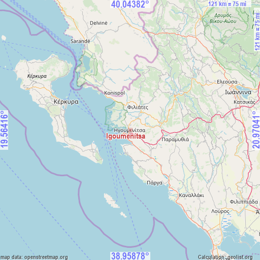
Igoumenítsa GPS coordinates[2]
39° 30' 12.312" North, 20° 16' 2.208" East
| Map corner | latitude | longitude |
|---|---|---|
| Upper-left | 40.04382°, | 19.56416° |
| Center: | 39.50342°, | 20.26728° |
| Lower-right: | 38.95878°, | 20.97041° |
| Map W x H: | 120.6×120.6 km | = 74.9×74.9mi |
| max Lat: | 41.72048° ⇑43.5% North |
| Igoumenítsa: | 39.50342° |
| min Lat: | ⇓56.5% South 34.8346° |
| min Long | Igoumenítsa | max Long |
| 19.40494° | 20.26728° | 29.59361° |
| W 2.8%⇐ | ⇒97.2% E |
Elevation
Elevation of Igoumenítsa is 29 m = 95 ft, and this is 139.9 m = 459 ft below average elevation for this country.
| Max E: |
1439 m = 4721 ft | 71.4% |
| Avg. | 168.9 m = 554 ft | |
| Igoumenítsa | 29 m = 95 ft | |
Min E: |
0 m = 0 ft | 28.6% |
See also: Greece elevation on elevation.city.
Geographical zone
Igoumenítsa is located in North temperate zone (between Tropic of Cancer and the Arctic Circle). Distance of this Northern Tropic circle is 1786.4 km =1110 mi to South.| Distance of | km | miles | from Igoumenítsa |
|---|---|---|---|
| North Pole | 5614.7 | 3488.8 | to North |
| Arctic Circle | 3008.8 | 1869.6 | to North |
| Tropic Cancer | 1786.4 | 1110 | to South |
| Equator | 4392.4 | 2729.3 | to South |


Nearby cities:
15 places around Igoumenítsa: (largest is in red/bold)
• Agiá
22.6 km =14 mi,  159°
159°
• Filiátes
11.5 km =7.1 mi,  19°
19°
• Graikochóri
1 km =0.6 mi,  129°
129°
• Kastrí
5.5 km =3.4 mi,  6°
6°
• Kávos
18.6 km =11.6 mi,  227°
227°
• Lefkímmi
19.1 km =11.9 mi,  242°
242°
• Margaríti
21.9 km =13.6 mi,  137°
137°
• Mazarakiá
13.2 km =8.2 mi, 135°
• Néa Seléfkeia
2.6 km =1.6 mi,  336°
336°
• Paramythiá
21.2 km =13.2 mi,  99°
99°
• Parapótamos
7 km =4.3 mi,  44°
44°
• Platariá
6 km =3.7 mi,  171°
171°
• Pérdika
15.2 km =9.4 mi, 167°
• Sagiáda
14.7 km =9.1 mi,  334°
334°
• Sývota
10.8 km =6.7 mi,  188°
188°
Sources, notices
• [Note1] Compared only with cities in Greece existing in our database
• [Src1] Map data: © OpenStreetMap contributors (CC-BY-SA)
• [Src2] Other city data from geonames.org with taken over terms of usage.
• [Src3] Geographical zone / Annual Mean Temperature by Robert A. Rohde @ Wikipedia
