Margaríti geodata
Margaríti (Epirus) is a populated place; located in Greece in Europe/Athens (GMT+3) time zone. With population of 857 people, there are 1188 cities with bigger population in this country. Compared to other cities in Greece, 52.7% of cities are located further ↓South; 96.6% of cities are located further →East and 70.7% of cities have lower elevation than Margaríti. Note1


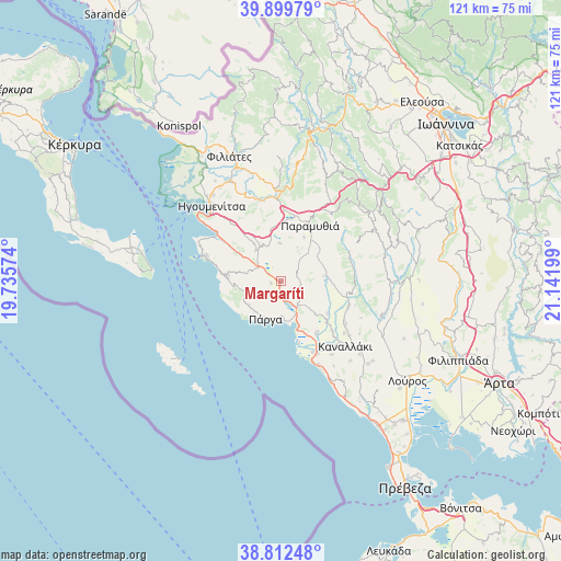
Margaríti GPS coordinates[2]
39° 21' 29.7" North, 20° 26' 19.896" East
| Map corner | latitude | longitude |
|---|---|---|
| Upper-left | 39.89979°, | 19.73574° |
| Center: | 39.35825°, | 20.43886° |
| Lower-right: | 38.81248°, | 21.14199° |
| Map W x H: | 120.9×120.9 km | = 75.1×75.1mi |
| max Lat: | 41.72048° ⇑47.3% North |
| Margaríti: | 39.35825° |
| min Lat: | ⇓52.7% South 34.8346° |
| min Long | Margaríti | max Long |
| 19.40494° | 20.43886° | 29.59361° |
| W 3.4%⇐ | ⇒96.6% E |
Elevation
Elevation of Margaríti is 171 m = 561 ft, and this is 2.1 m = 7 ft above average elevation for this country.
| Max E: |
1439 m = 4721 ft | 29.3% |
| Margaríti | 171 m 561 ft | |
| Avg. | 168.9 m = 554 ft | |
Min E: |
0 m = 0 ft | 70.7% |
See also: Greece elevation on elevation.city.
Geographical zone
Margaríti is located in North temperate zone (between Tropic of Cancer and the Arctic Circle). Distance of this Northern Tropic circle is 1770.3 km =1100 mi to South.| Distance of | km | miles | from Margaríti |
|---|---|---|---|
| North Pole | 5630.8 | 3498.8 | to North |
| Arctic Circle | 3024.9 | 1879.6 | to North |
| Tropic Cancer | 1770.3 | 1100 | to South |
| Equator | 4376.2 | 2719.2 | to South |


Nearby cities:
15 places around Margaríti: (largest is in red/bold)
• Agiá
8.5 km =5.3 mi,  233°
233°
• Anthoúsa
8.7 km =5.4 mi,  220°
220°
• Gardíki
10.8 km =6.7 mi,  89°
89°
• Graikochóri
20.9 km =13 mi,  317°
317°
• Igoumenítsa
21.9 km =13.6 mi, 317°
• Kanaláki
19.6 km =12.2 mi,  134°
134°
• Mazarakiá
8.6 km =5.3 mi, 320°
• Mesopótamo
15.5 km =9.6 mi,  149°
149°
• Paramythiá
14 km =8.7 mi,  26°
26°
• Parapótamos
23.3 km =14.5 mi,  335°
335°
• Platariá
17.2 km =10.7 mi,  306°
306°
• Párga
8.7 km =5.4 mi,  202°
202°
• Pérdika
11.6 km =7.2 mi,  276°
276°
• Sývota
17.3 km =10.7 mi,  288°
288°
• Vouvopótamos
15.6 km =9.7 mi,  110°
110°
Sources, notices
• [Note1] Compared only with cities in Greece existing in our database
• [Src1] Map data: © OpenStreetMap contributors (CC-BY-SA)
• [Src2] Other city data from geonames.org with taken over terms of usage.
• [Src3] Geographical zone / Annual Mean Temperature by Robert A. Rohde @ Wikipedia
