Mazarakiá geodata
Mazarakiá (Epirus) is a populated place; located in Greece in Europe/Athens (GMT+3) time zone. With population of 558 people, there are 1683 cities with bigger population in this country. Compared to other cities in Greece, 54.2% of cities are located further ↓South; 96.8% of cities are located further →East and 68.3% of cities have lower elevation than Mazarakiá. Note1


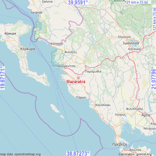
Mazarakiá GPS coordinates[2]
39° 25' 4.908" North, 20° 22' 29.388" East
| Map corner | latitude | longitude |
|---|---|---|
| Upper-left | 39.9591°, | 19.67171° |
| Center: | 39.41803°, | 20.37483° |
| Lower-right: | 38.87273°, | 21.07796° |
| Map W x H: | 120.8×120.8 km | = 75.1×75.1mi |
| max Lat: | 41.72048° ⇑45.8% North |
| Mazarakiá: | 39.41803° |
| min Lat: | ⇓54.2% South 34.8346° |
| min Long | Mazarakiá | max Long |
| 19.40494° | 20.37483° | 29.59361° |
| W 3.2%⇐ | ⇒96.8% E |
Elevation
Elevation of Mazarakiá is 154 m = 505 ft, and this is 14.9 m = 49 ft below average elevation for this country.
| Max E: |
1439 m = 4721 ft | 31.7% |
| Avg. | 168.9 m = 554 ft | |
| Mazarakiá | 154 m = 505 ft | |
Min E: |
0 m = 0 ft | 68.3% |
See also: Greece elevation on elevation.city.
Geographical zone
Mazarakiá is located in North temperate zone (between Tropic of Cancer and the Arctic Circle). Distance of this Northern Tropic circle is 1777 km =1104.2 mi to South.| Distance of | km | miles | from Mazarakiá |
|---|---|---|---|
| North Pole | 5624.2 | 3494.7 | to North |
| Arctic Circle | 3018.3 | 1875.5 | to North |
| Tropic Cancer | 1777 | 1104.2 | to South |
| Equator | 4382.9 | 2723.4 | to South |


Nearby cities:
15 places around Mazarakiá: (largest is in red/bold)
• Agiá
11.8 km =7.3 mi,  186°
186°
• Anthoúsa
13.2 km =8.2 mi,  180°
180°
• Filiátes
21.1 km =13.1 mi,  345°
345°
• Gardíki
17.6 km =10.9 mi,  111°
111°
• Graikochóri
12.3 km =7.6 mi,  316°
316°
• Igoumenítsa
13.2 km =8.2 mi, 315°
• Kastrí
17.3 km =10.7 mi,  329°
329°
• Margaríti
8.6 km =5.3 mi,  140°
140°
• Néa Seléfkeia
15.7 km =9.8 mi, 319°
• Paramythiá
13.1 km =8.1 mi,  63°
63°
• Parapótamos
15.1 km =9.4 mi,  343°
343°
• Platariá
9.1 km =5.7 mi,  293°
293°
• Párga
14.9 km =9.3 mi,  171°
171°
• Pérdika
8.1 km =5 mi,  228°
228°
• Sývota
10.9 km =6.8 mi,  263°
263°
Sources, notices
• [Note1] Compared only with cities in Greece existing in our database
• [Src1] Map data: © OpenStreetMap contributors (CC-BY-SA)
• [Src2] Other city data from geonames.org with taken over terms of usage.
• [Src3] Geographical zone / Annual Mean Temperature by Robert A. Rohde @ Wikipedia
