Sývota geodata
Sývota (Epirus) is a populated place; located in Greece in Europe/Athens (GMT+3) time zone. With population of 973 people, there are 1049 cities with bigger population in this country. Compared to other cities in Greece, 54% of cities are located further ↓South; 97.3% of cities are located further →East and 79.3% of cities have higher elevation than Sývota. Note1


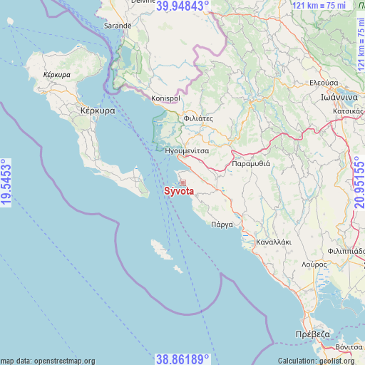
Sývota GPS coordinates[2]
39° 24' 26.208" North, 20° 14' 54.312" East
| Map corner | latitude | longitude |
|---|---|---|
| Upper-left | 39.94843°, | 19.5453° |
| Center: | 39.40728°, | 20.24842° |
| Lower-right: | 38.86189°, | 20.95155° |
| Map W x H: | 120.8×120.8 km | = 75.1×75.1mi |
| max Lat: | 41.72048° ⇑46% North |
| Sývota: | 39.40728° |
| min Lat: | ⇓54% South 34.8346° |
| min Long | Sývota | max Long |
| 19.40494° | 20.24842° | 29.59361° |
| W 2.7%⇐ | ⇒97.3% E |
Elevation
Elevation of Sývota is 18 m = 59 ft, and this is 150.9 m = 495 ft below average elevation for this country.
| Max E: |
1439 m = 4721 ft | 79.3% |
| Avg. | 168.9 m = 554 ft | |
| Sývota | 18 m = 59 ft | |
Min E: |
0 m = 0 ft | 20.7% |
See also: Greece elevation on elevation.city.
Geographical zone
Sývota is located in North temperate zone (between Tropic of Cancer and the Arctic Circle). Distance of this Northern Tropic circle is 1775.8 km =1103.4 mi to South.| Distance of | km | miles | from Sývota |
|---|---|---|---|
| North Pole | 5625.4 | 3495.5 | to North |
| Arctic Circle | 3019.5 | 1876.2 | to North |
| Tropic Cancer | 1775.8 | 1103.4 | to South |
| Equator | 4381.7 | 2722.7 | to South |


Nearby cities:
15 places around Sývota: (largest is in red/bold)
• Agiá
14.1 km =8.8 mi,  137°
137°
• Anthoúsa
16.1 km =10 mi, 138°
• Graikochóri
10.4 km =6.5 mi,  13°
13°
• Igoumenítsa
10.8 km =6.7 mi, 8°
• Kastrí
16.3 km =10.1 mi, 7°
• Kávos
12.2 km =7.6 mi,  261°
261°
• Lefkímmi
15.4 km =9.6 mi,  276°
276°
• Margaríti
17.3 km =10.7 mi,  108°
108°
• Mazarakiá
10.9 km =6.8 mi,  83°
83°
• Néa Seléfkeia
13.1 km =8.1 mi,  2°
2°
• Parapótamos
17 km =10.6 mi,  22°
22°
• Perivóli
20.1 km =12.5 mi,  273°
273°
• Platariá
5.4 km =3.4 mi,  27°
27°
• Párga
18.8 km =11.7 mi, 135°
• Pérdika
6.4 km =4 mi,  131°
131°
Sources, notices
• [Note1] Compared only with cities in Greece existing in our database
• [Src1] Map data: © OpenStreetMap contributors (CC-BY-SA)
• [Src2] Other city data from geonames.org with taken over terms of usage.
• [Src3] Geographical zone / Annual Mean Temperature by Robert A. Rohde @ Wikipedia
