Palamás geodata
Palamás (Thessaly) is a seat of a third-order administrative division; located in Greece in Europe/Athens (GMT+3) time zone. With population of 5,719 people, there are 214 cities with bigger population in this country. Compared to other cities in Greece, 55.7% of cities are located further ↓South; 70.1% of cities are located further →East and 53% of cities have lower elevation than Palamás. Note1


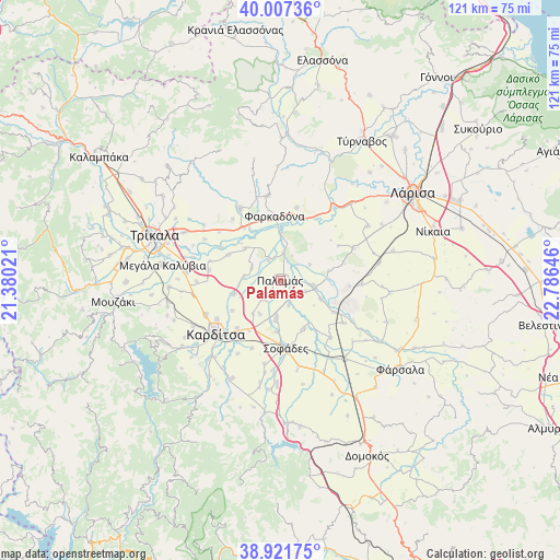
Palamás GPS coordinates[2]
39° 28' 0.012" North, 22° 4' 59.988" East
| Map corner | latitude | longitude |
|---|---|---|
| Upper-left | 40.00736°, | 21.38021° |
| Center: | 39.46667°, | 22.08333° |
| Lower-right: | 38.92175°, | 22.78646° |
| Map W x H: | 120.7×120.7 km | = 75×75mi |
| max Lat: | 41.72048° ⇑44.3% North |
| Palamás: | 39.46667° |
| min Lat: | ⇓55.7% South 34.8346° |
| min Long | Palamás | max Long |
| 19.40494° | 22.08333° | 29.59361° |
| W 29.9%⇐ | ⇒70.1% E |
Elevation
Elevation of Palamás is 92 m = 302 ft, and this is 76.9 m = 252 ft below average elevation for this country.
| Max E: |
1439 m = 4721 ft | 47% |
| Avg. | 168.9 m = 554 ft | |
| Palamás | 92 m = 302 ft | |
Min E: |
0 m = 0 ft | 53% |
See also: Greece elevation on elevation.city.
Geographical zone
Palamás is located in North temperate zone (between Tropic of Cancer and the Arctic Circle). Distance of this Northern Tropic circle is 1782.4 km =1107.5 mi to South.| Distance of | km | miles | from Palamás |
|---|---|---|---|
| North Pole | 5618.8 | 3491.4 | to North |
| Arctic Circle | 3012.9 | 1872.1 | to North |
| Tropic Cancer | 1782.4 | 1107.5 | to South |
| Equator | 4388.3 | 2726.8 | to South |


Nearby cities:
15 places around Palamás: (largest is in red/bold)
• Agía Triáda
15.9 km =9.9 mi,  268°
268°
• Farkadóna
14.9 km =9.3 mi,  354°
354°
• Itéa
7.2 km =4.5 mi,  98°
98°
• Karditsomagoúla
16.1 km =10 mi,  238°
238°
• Karpochóri
15.8 km =9.8 mi,  203°
203°
• Makrychóri
10.5 km =6.5 mi,  253°
253°
• Marathéa
10.4 km =6.5 mi,  312°
312°
• Mýrina
12.2 km =7.6 mi, 237°
• Pedinó
12.6 km =7.8 mi,  297°
297°
• Proástio
15.6 km =9.7 mi,  278°
278°
• Pródromos
13.7 km =8.5 mi,  222°
222°
• Servotá
15.7 km =9.8 mi,  285°
285°
• Sofádes
14.9 km =9.3 mi,  174°
174°
• Stavrós
15.1 km =9.4 mi, 219°
• Zárkos
16.2 km =10.1 mi,  12°
12°
Sources, notices
• [Note1] Compared only with cities in Greece existing in our database
• [Src1] Map data: © OpenStreetMap contributors (CC-BY-SA)
• [Src2] Other city data from geonames.org with taken over terms of usage.
• [Src3] Geographical zone / Annual Mean Temperature by Robert A. Rohde @ Wikipedia
