Moláoi geodata
Moláoi (Peloponnese) is a seat of a third-order administrative division; located in Greece in Europe/Athens (GMT+3) time zone. With population of 3,018 people, there are 347 cities with bigger population in this country. Compared to other cities in Greece, 91.3% of cities are located further ↑North; 50.1% of cities are located further →East and 74.9% of cities have lower elevation than Moláoi. Note1


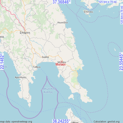
Moláoi GPS coordinates[2]
36° 48' 27.252" North, 22° 51' 4.752" East
| Map corner | latitude | longitude |
|---|---|---|
| Upper-left | 37.36846°, | 22.1482° |
| Center: | 36.80757°, | 22.85132° |
| Lower-right: | 36.24255°, | 23.55445° |
| Map W x H: | 125.2×125.2 km | = 77.8×77.8mi |
| max Lat: | 41.72048° ⇑91.3% North |
| Moláoi: | 36.80757° |
| min Lat: | ⇓8.7% South 34.8346° |
| min Long | Moláoi | max Long |
| 19.40494° | 22.85132° | 29.59361° |
| W 49.9%⇐ | ⇒50.1% E |
Elevation
Elevation of Moláoi is 208 m = 682 ft, and this is 39.1 m = 128 ft above average elevation for this country.
| Max E: |
1439 m = 4721 ft | 25.1% |
| Moláoi | 208 m 682 ft | |
| Avg. | 168.9 m = 554 ft | |
Min E: |
0 m = 0 ft | 74.9% |
See also: Greece elevation on elevation.city.
Geographical zone
Moláoi is located in North temperate zone (between Tropic of Cancer and the Arctic Circle). Distance of this Northern Tropic circle is 1486.7 km =923.8 mi to South.| Distance of | km | miles | from Moláoi |
|---|---|---|---|
| North Pole | 5914.4 | 3675 | to North |
| Arctic Circle | 3308.6 | 2055.9 | to North |
| Tropic Cancer | 1486.7 | 923.8 | to South |
| Equator | 4092.6 | 2543 | to South |


Nearby cities:
15 places around Moláoi: (largest is in red/bold)
• Areópoli
44.7 km =27.8 mi,  249°
249°
• Asopós
8.6 km =5.3 mi,  178°
178°
• Elafónisos
35.2 km =21.9 mi,  161°
161°
• Geráki
24.2 km =15 mi,  327°
327°
• Géfyra
21.2 km =13.2 mi,  129°
129°
• Gýtheio
26.2 km =16.3 mi,  257°
257°
• Krokeés
28.4 km =17.6 mi,  287°
287°
• Káto Glykóvrysi
7 km =4.3 mi, 288°
• Leonídio
39.9 km =24.8 mi,  0°
0°
• Poúlithra
33.7 km =20.9 mi,  5°
5°
• Skála
17.1 km =10.6 mi, 286°
• Sykiá
9.5 km =5.9 mi,  120°
120°
• Vlachiótis
14 km =8.7 mi, 294°
• Xirokámbion
39.3 km =24.4 mi,  295°
295°
• Élos
13.9 km =8.6 mi,  281°
281°
Sources, notices
• [Note1] Compared only with cities in Greece existing in our database
• [Src1] Map data: © OpenStreetMap contributors (CC-BY-SA)
• [Src2] Other city data from geonames.org with taken over terms of usage.
• [Src3] Geographical zone / Annual Mean Temperature by Robert A. Rohde @ Wikipedia
