Élos geodata
Élos (Peloponnese) is a populated place; located in Greece in Europe/Athens (GMT+3) time zone. With population of 956 people, there are 1066 cities with bigger population in this country. Compared to other cities in Greece, 91% of cities are located further ↑North; 55.3% of cities are located further →East and 90.7% of cities have higher elevation than Élos. Note1


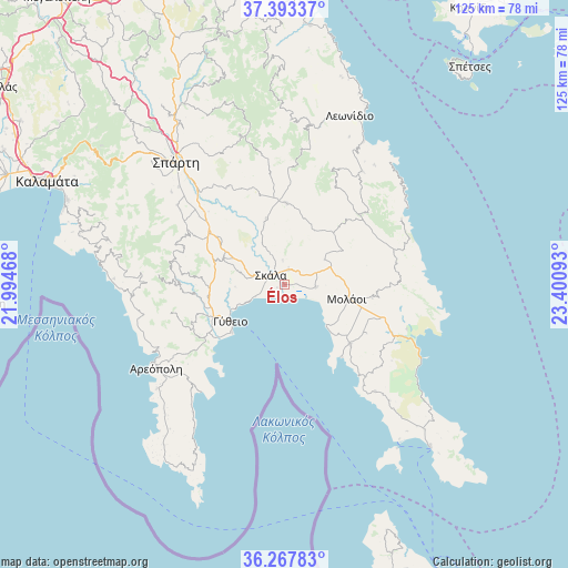
Élos GPS coordinates[2]
36° 49' 57.612" North, 22° 41' 52.08" East
| Map corner | latitude | longitude |
|---|---|---|
| Upper-left | 37.39337°, | 21.99468° |
| Center: | 36.83267°, | 22.6978° |
| Lower-right: | 36.26783°, | 23.40093° |
| Map W x H: | 125.1×125.1 km | = 77.7×77.7mi |
| max Lat: | 41.72048° ⇑91% North |
| Élos: | 36.83267° |
| min Lat: | ⇓9% South 34.8346° |
| min Long | Élos | max Long |
| 19.40494° | 22.6978° | 29.59361° |
| W 44.7%⇐ | ⇒55.3% E |
Elevation
Elevation of Élos is 8 m = 26 ft, and this is 160.9 m = 528 ft below average elevation for this country.
| Max E: |
1439 m = 4721 ft | 90.7% |
| Avg. | 168.9 m = 554 ft | |
| Élos | 8 m = 26 ft | |
Min E: |
0 m = 0 ft | 9.3% |
See also: Greece elevation on elevation.city.
Geographical zone
Élos is located in North temperate zone (between Tropic of Cancer and the Arctic Circle). Distance of this Northern Tropic circle is 1489.5 km =925.5 mi to South.| Distance of | km | miles | from Élos |
|---|---|---|---|
| North Pole | 5911.7 | 3673.4 | to North |
| Arctic Circle | 3305.8 | 2054.1 | to North |
| Tropic Cancer | 1489.5 | 925.5 | to South |
| Equator | 4095.4 | 2544.8 | to South |


Nearby cities:
15 places around Élos: (largest is in red/bold)
• Areópoli
33.7 km =20.9 mi,  236°
236°
• Asopós
18 km =11.2 mi,  129°
129°
• Geráki
17.8 km =11.1 mi,  2°
2°
• Géfyra
34.1 km =21.2 mi,  118°
118°
• Gýtheio
14.7 km =9.1 mi,  234°
234°
• Krokeés
14.5 km =9 mi,  292°
292°
• Káto Glykóvrysi
7.1 km =4.4 mi,  94°
94°
• Magoúla
37.9 km =23.5 mi,  316°
316°
• Moláoi
13.9 km =8.6 mi,  101°
101°
• Poúlithra
35 km =21.7 mi,  28°
28°
• Skála
3.4 km =2.1 mi,  304°
304°
• Spárti
35.9 km =22.3 mi, 318°
• Sykiá
23.1 km =14.4 mi,  109°
109°
• Vlachiótis
3.3 km =2.1 mi,  16°
16°
• Xirokámbion
26 km =16.2 mi, 302°
Sources, notices
• [Note1] Compared only with cities in Greece existing in our database
• [Src1] Map data: © OpenStreetMap contributors (CC-BY-SA)
• [Src2] Other city data from geonames.org with taken over terms of usage.
• [Src3] Geographical zone / Annual Mean Temperature by Robert A. Rohde @ Wikipedia
