Krokeés geodata
Krokeés (Peloponnese) is a populated place; located in Greece in Europe/Athens (GMT+3) time zone. With population of 1,329 people, there are 757 cities with bigger population in this country. Compared to other cities in Greece, 90.6% of cities are located further ↑North; 58.5% of cities are located further →East and 81.5% of cities have lower elevation than Krokeés. Note1


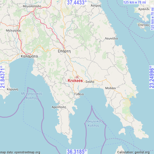
Krokeés GPS coordinates[2]
36° 52' 58.692" North, 22° 32' 48.588" East
| Map corner | latitude | longitude |
|---|---|---|
| Upper-left | 37.4433°, | 21.84371° |
| Center: | 36.88297°, | 22.54683° |
| Lower-right: | 36.3185°, | 23.24996° |
| Map W x H: | 125.1×125.1 km | = 77.7×77.7mi |
| max Lat: | 41.72048° ⇑90.6% North |
| Krokeés: | 36.88297° |
| min Lat: | ⇓9.4% South 34.8346° |
| min Long | Krokeés | max Long |
| 19.40494° | 22.54683° | 29.59361° |
| W 41.5%⇐ | ⇒58.5% E |
Elevation
Elevation of Krokeés is 309 m = 1014 ft, and this is 140.1 m = 460 ft above average elevation for this country.
| Max E: |
1439 m = 4721 ft | 18.5% |
| Krokeés | 309 m 1014 ft | |
| Avg. | 168.9 m = 554 ft | |
Min E: |
0 m = 0 ft | 81.5% |
See also: Greece elevation on elevation.city.
Geographical zone
Krokeés is located in North temperate zone (between Tropic of Cancer and the Arctic Circle). Distance of this Northern Tropic circle is 1495.1 km =929 mi to South.| Distance of | km | miles | from Krokeés |
|---|---|---|---|
| North Pole | 5906.1 | 3669.9 | to North |
| Arctic Circle | 3300.2 | 2050.6 | to North |
| Tropic Cancer | 1495.1 | 929 | to South |
| Equator | 4101 | 2548.2 | to South |


Nearby cities:
15 places around Krokeés: (largest is in red/bold)
• Areópoli
28.3 km =17.6 mi,  211°
211°
• Asopós
32.3 km =20.1 mi,  121°
121°
• Geráki
18.7 km =11.6 mi,  49°
49°
• Gýtheio
14.3 km =8.9 mi,  173°
173°
• Kardamýli
27.9 km =17.3 mi,  271°
271°
• Káto Glykóvrysi
21.4 km =13.3 mi,  106°
106°
• Magoúla
25.3 km =15.7 mi,  330°
330°
• Mikrá Mantíneia
36.8 km =22.9 mi,  288°
288°
• Moláoi
28.4 km =17.6 mi, 107°
• Skála
11.3 km =7 mi, 108°
• Spárti
23.7 km =14.7 mi, 334°
• Stoúpa
25.9 km =16.1 mi,  260°
260°
• Vlachiótis
14.6 km =9.1 mi,  99°
99°
• Xirokámbion
12 km =7.5 mi,  315°
315°
• Élos
14.5 km =9 mi, 112°
Sources, notices
• [Note1] Compared only with cities in Greece existing in our database
• [Src1] Map data: © OpenStreetMap contributors (CC-BY-SA)
• [Src2] Other city data from geonames.org with taken over terms of usage.
• [Src3] Geographical zone / Annual Mean Temperature by Robert A. Rohde @ Wikipedia
