Metsovo geodata
Metsovo (Epirus) is a seat of a third-order administrative division; located in Greece in Europe/Athens (GMT+3) time zone. With population of 2,503 people, there are 420 cities with bigger population in this country. Compared to other cities in Greece, 64% of cities are located further ↓South; 88% of cities are located further →East and 99.9% of cities have lower elevation than Metsovo. Note1


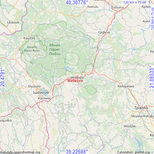
Metsovo GPS coordinates[2]
39° 46' 9.984" North, 21° 10' 55.992" East
| Map corner | latitude | longitude |
|---|---|---|
| Upper-left | 40.30776°, | 20.4791° |
| Center: | 39.76944°, | 21.18222° |
| Lower-right: | 39.22688°, | 21.88535° |
| Map W x H: | 120.2×120.2 km | = 74.7×74.7mi |
| max Lat: | 41.72048° ⇑36% North |
| Metsovo: | 39.76944° |
| min Lat: | ⇓64% South 34.8346° |
| min Long | Metsovo | max Long |
| 19.40494° | 21.18222° | 29.59361° |
| W 12%⇐ | ⇒88% E |
Elevation
Elevation of Metsovo is 1145 m = 3757 ft, and this is 976.1 m = 3202 ft above average elevation for this country.
| Max E: |
1439 m = 4721 ft | 0.099999999999994% |
| Metsovo | 1145 m 3757 ft | |
| Avg. | 168.9 m = 554 ft | |
Min E: |
0 m = 0 ft | 99.9% |
See also: Greece elevation on elevation.city.
Geographical zone
Metsovo is located in North temperate zone (between Tropic of Cancer and the Arctic Circle). Distance of this Northern Tropic circle is 1816 km =1128.4 mi to South.| Distance of | km | miles | from Metsovo |
|---|---|---|---|
| North Pole | 5585.1 | 3470.4 | to North |
| Arctic Circle | 2979.2 | 1851.2 | to North |
| Tropic Cancer | 1816 | 1128.4 | to South |
| Equator | 4421.9 | 2747.6 | to South |


Nearby cities:
15 places around Metsovo: (largest is in red/bold)
• Agnantiá
26.6 km =16.5 mi,  65°
65°
• Amfithéa
28.5 km =17.7 mi,  252°
252°
• Anílio
1.2 km =0.7 mi,  150°
150°
• Drosochóri
23.9 km =14.9 mi,  228°
228°
• Iliókali
25 km =15.5 mi, 227°
• Kalomoíra
19.7 km =12.2 mi,  96°
96°
• Kastrítsa
27.1 km =16.8 mi,  235°
235°
• Kraniá
16.5 km =10.3 mi,  30°
30°
• Longádes
24.1 km =15 mi, 239°
• Malakási
8.8 km =5.5 mi,  81°
81°
• Melissourgoí
29.1 km =18.1 mi,  186°
186°
• Oxýneia
27 km =16.8 mi, 76°
• Panagía
12.9 km =8 mi, 76°
• Prámanta
28.3 km =17.6 mi, 194°
• Pérama
29.9 km =18.6 mi, 253°
Sources, notices
• [Note1] Compared only with cities in Greece existing in our database
• [Src1] Map data: © OpenStreetMap contributors (CC-BY-SA)
• [Src2] Other city data from geonames.org with taken over terms of usage.
• [Src3] Geographical zone / Annual Mean Temperature by Robert A. Rohde @ Wikipedia
