Mesopótamo geodata
Mesopótamo (Epirus) is a populated place; located in Greece in Europe/Athens (GMT+3) time zone. With population of 503 people, there are 1797 cities with bigger population in this country. Compared to other cities in Greece, 50.2% of cities are located further ↓South; 96.3% of cities are located further →East and 92.5% of cities have higher elevation than Mesopótamo. Note1


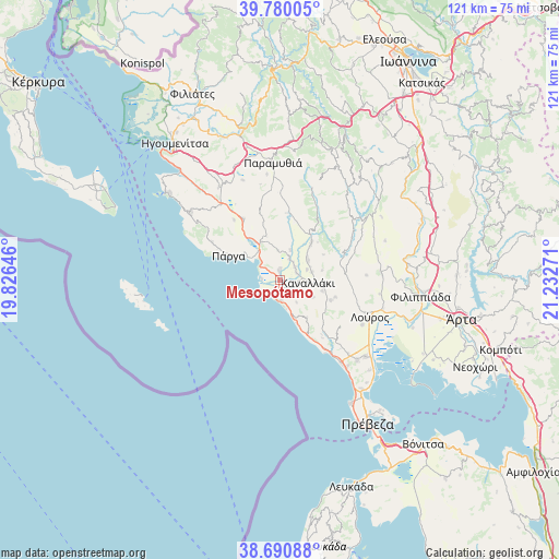
Mesopótamo GPS coordinates[2]
39° 14' 15.288" North, 20° 31' 46.488" East
| Map corner | latitude | longitude |
|---|---|---|
| Upper-left | 39.78005°, | 19.82646° |
| Center: | 39.23758°, | 20.52958° |
| Lower-right: | 38.69088°, | 21.23271° |
| Map W x H: | 121.1×121.1 km | = 75.2×75.2mi |
| max Lat: | 41.72048° ⇑49.8% North |
| Mesopótamo: | 39.23758° |
| min Lat: | ⇓50.2% South 34.8346° |
| min Long | Mesopótamo | max Long |
| 19.40494° | 20.52958° | 29.59361° |
| W 3.7%⇐ | ⇒96.3% E |
Elevation
Elevation of Mesopótamo is 7 m = 23 ft, and this is 161.9 m = 531 ft below average elevation for this country.
| Max E: |
1439 m = 4721 ft | 92.5% |
| Avg. | 168.9 m = 554 ft | |
| Mesopótamo | 7 m = 23 ft | |
Min E: |
0 m = 0 ft | 7.5% |
See also: Greece elevation on elevation.city.
Geographical zone
Mesopótamo is located in North temperate zone (between Tropic of Cancer and the Arctic Circle). Distance of this Northern Tropic circle is 1756.9 km =1091.7 mi to South.| Distance of | km | miles | from Mesopótamo |
|---|---|---|---|
| North Pole | 5644.3 | 3507.2 | to North |
| Arctic Circle | 3038.4 | 1888 | to North |
| Tropic Cancer | 1756.9 | 1091.7 | to South |
| Equator | 4362.8 | 2710.9 | to South |


Nearby cities:
15 places around Mesopótamo: (largest is in red/bold)
• Agiá
16.9 km =10.5 mi,  299°
299°
• Anthoúsa
15.1 km =9.4 mi, 296°
• Gardíki
13.8 km =8.6 mi,  12°
12°
• Kanaláki
6.1 km =3.8 mi,  94°
94°
• Kanáli
23.7 km =14.7 mi,  141°
141°
• Kranéa
18.8 km =11.7 mi, 86°
• Loúros
21.1 km =13.1 mi,  112°
112°
• Margaríti
15.5 km =9.6 mi,  329°
329°
• Néa Sinópi
24 km =14.9 mi, 135°
• Néos Oropós
20.3 km =12.6 mi,  118°
118°
• Oropós
18.2 km =11.3 mi, 116°
• Párga
12.3 km =7.6 mi, 295°
• Stefáni
23.3 km =14.5 mi, 105°
• Thesprotikó
22.1 km =13.7 mi, 86°
• Vouvopótamos
10.6 km =6.6 mi,  40°
40°
Sources, notices
• [Note1] Compared only with cities in Greece existing in our database
• [Src1] Map data: © OpenStreetMap contributors (CC-BY-SA)
• [Src2] Other city data from geonames.org with taken over terms of usage.
• [Src3] Geographical zone / Annual Mean Temperature by Robert A. Rohde @ Wikipedia
