Anthoúsa geodata
Anthoúsa (Epirus) is a populated place; located in Greece in Europe/Athens (GMT+3) time zone. With population of 586 people, there are 1609 cities with bigger population in this country. Compared to other cities in Greece, 51.3% of cities are located further ↓South; 96.8% of cities are located further →East and 72.8% of cities have lower elevation than Anthoúsa. Note1


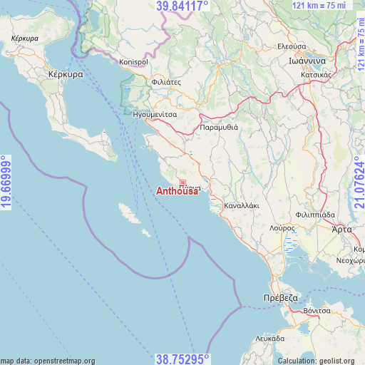
Anthoúsa GPS coordinates[2]
39° 17' 57.012" North, 20° 22' 23.196" East
| Map corner | latitude | longitude |
|---|---|---|
| Upper-left | 39.84117°, | 19.66999° |
| Center: | 39.29917°, | 20.37311° |
| Lower-right: | 38.75295°, | 21.07624° |
| Map W x H: | 121×121 km | = 75.2×75.2mi |
| max Lat: | 41.72048° ⇑48.7% North |
| Anthoúsa: | 39.29917° |
| min Lat: | ⇓51.3% South 34.8346° |
| min Long | Anthoúsa | max Long |
| 19.40494° | 20.37311° | 29.59361° |
| W 3.2%⇐ | ⇒96.8% E |
Elevation
Elevation of Anthoúsa is 187 m = 614 ft, and this is 18.1 m = 59 ft above average elevation for this country.
| Max E: |
1439 m = 4721 ft | 27.2% |
| Anthoúsa | 187 m 614 ft | |
| Avg. | 168.9 m = 554 ft | |
Min E: |
0 m = 0 ft | 72.8% |
See also: Greece elevation on elevation.city.
Geographical zone
Anthoúsa is located in North temperate zone (between Tropic of Cancer and the Arctic Circle). Distance of this Northern Tropic circle is 1763.7 km =1095.9 mi to South.| Distance of | km | miles | from Anthoúsa |
|---|---|---|---|
| North Pole | 5637.4 | 3502.9 | to North |
| Arctic Circle | 3031.5 | 1883.7 | to North |
| Tropic Cancer | 1763.7 | 1095.9 | to South |
| Equator | 4369.7 | 2715.2 | to South |


Nearby cities:
15 places around Anthoúsa: (largest is in red/bold)
• Agiá
2 km =1.2 mi,  320°
320°
• Gardíki
17.8 km =11.1 mi,  68°
68°
• Graikochóri
23.6 km =14.7 mi,  339°
339°
• Gáïos
19.7 km =12.2 mi,  234°
234°
• Igoumenítsa
24.5 km =15.2 mi, 338°
• Kanaláki
20.8 km =12.9 mi,  110°
110°
• Margaríti
8.7 km =5.4 mi,  40°
40°
• Mazarakiá
13.2 km =8.2 mi,  0°
0°
• Mesopótamo
15.1 km =9.4 mi,  116°
116°
• Paramythiá
22.5 km =14 mi,  31°
31°
• Platariá
18.7 km =11.6 mi,  334°
334°
• Párga
2.8 km =1.7 mi, 122°
• Pérdika
9.8 km =6.1 mi, 322°
• Sývota
16.1 km =10 mi, 318°
• Vouvopótamos
20.3 km =12.6 mi,  86°
86°
Sources, notices
• [Note1] Compared only with cities in Greece existing in our database
• [Src1] Map data: © OpenStreetMap contributors (CC-BY-SA)
• [Src2] Other city data from geonames.org with taken over terms of usage.
• [Src3] Geographical zone / Annual Mean Temperature by Robert A. Rohde @ Wikipedia
