Kanaláki geodata
Kanaláki (Epirus) is a seat of a third-order administrative division; located in Greece in Europe/Athens (GMT+3) time zone. With population of 2,446 people, there are 430 cities with bigger population in this country. Compared to other cities in Greece, 50.1% of cities are located further ↓South; 96% of cities are located further →East and 73% of cities have higher elevation than Kanaláki. Note1


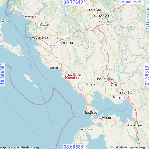
Kanaláki GPS coordinates[2]
39° 14' 0.996" North, 20° 36' 0" East
| Map corner | latitude | longitude |
|---|---|---|
| Upper-left | 39.77612°, | 19.89688° |
| Center: | 39.23361°, | 20.6° |
| Lower-right: | 38.68688°, | 21.30313° |
| Map W x H: | 121.1×121.1 km | = 75.2×75.2mi |
| max Lat: | 41.72048° ⇑49.9% North |
| Kanaláki: | 39.23361° |
| min Lat: | ⇓50.1% South 34.8346° |
| min Long | Kanaláki | max Long |
| 19.40494° | 20.6° | 29.59361° |
| W 4%⇐ | ⇒96% E |
Elevation
Elevation of Kanaláki is 26 m = 85 ft, and this is 142.9 m = 469 ft below average elevation for this country.
| Max E: |
1439 m = 4721 ft | 73% |
| Avg. | 168.9 m = 554 ft | |
| Kanaláki | 26 m = 85 ft | |
Min E: |
0 m = 0 ft | 27% |
See also: Greece elevation on elevation.city.
Geographical zone
Kanaláki is located in North temperate zone (between Tropic of Cancer and the Arctic Circle). Distance of this Northern Tropic circle is 1756.4 km =1091.4 mi to South.| Distance of | km | miles | from Kanaláki |
|---|---|---|---|
| North Pole | 5644.7 | 3507.5 | to North |
| Arctic Circle | 3038.8 | 1888.2 | to North |
| Tropic Cancer | 1756.4 | 1091.4 | to South |
| Equator | 4362.4 | 2710.7 | to South |


Nearby cities:
15 places around Kanaláki: (largest is in red/bold)
• Gardíki
14.3 km =8.9 mi,  347°
347°
• Kanáli
20.1 km =12.5 mi,  154°
154°
• Kranéa
12.8 km =8 mi,  83°
83°
• Loúros
15.4 km =9.6 mi,  119°
119°
• Margaríti
19.6 km =12.2 mi,  314°
314°
• Mesopótamo
6.1 km =3.8 mi,  274°
274°
• Néa Sinópi
19.9 km =12.4 mi, 147°
• Néos Oropós
14.9 km =9.3 mi,  128°
128°
• Oropós
12.8 km =8 mi, 127°
• Pappadátes
18.9 km =11.7 mi,  61°
61°
• Párga
18.1 km =11.2 mi,  288°
288°
• Rizovoúni
18.4 km =11.4 mi, 81°
• Stefáni
17.4 km =10.8 mi,  109°
109°
• Thesprotikó
16.1 km =10 mi, 83°
• Vouvopótamos
8.6 km =5.3 mi,  5°
5°
Sources, notices
• [Note1] Compared only with cities in Greece existing in our database
• [Src1] Map data: © OpenStreetMap contributors (CC-BY-SA)
• [Src2] Other city data from geonames.org with taken over terms of usage.
• [Src3] Geographical zone / Annual Mean Temperature by Robert A. Rohde @ Wikipedia
