Melívoia geodata
Melívoia (Thessaly) is a populated place; located in Greece in Europe/Athens (GMT+3) time zone. With population of 805 people, there are 1270 cities with bigger population in this country. Compared to other cities in Greece, 63.7% of cities are located further ↓South; 51.7% of cities are located further →East and 86.1% of cities have lower elevation than Melívoia. Note1


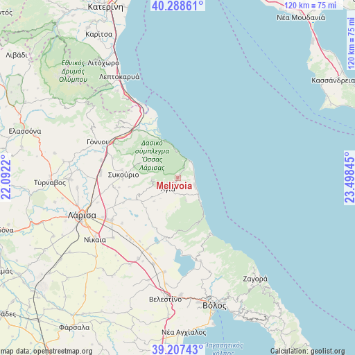
Melívoia GPS coordinates[2]
39° 45' 0.504" North, 22° 47' 43.152" East
| Map corner | latitude | longitude |
|---|---|---|
| Upper-left | 40.28861°, | 22.0922° |
| Center: | 39.75014°, | 22.79532° |
| Lower-right: | 39.20743°, | 23.49845° |
| Map W x H: | 120.2×120.2 km | = 74.7×74.7mi |
| max Lat: | 41.72048° ⇑36.3% North |
| Melívoia: | 39.75014° |
| min Lat: | ⇓63.7% South 34.8346° |
| min Long | Melívoia | max Long |
| 19.40494° | 22.79532° | 29.59361° |
| W 48.3%⇐ | ⇒51.7% E |
Elevation
Elevation of Melívoia is 406 m = 1332 ft, and this is 237.1 m = 778 ft above average elevation for this country.
| Max E: |
1439 m = 4721 ft | 13.9% |
| Melívoia | 406 m 1332 ft | |
| Avg. | 168.9 m = 554 ft | |
Min E: |
0 m = 0 ft | 86.1% |
See also: Greece elevation on elevation.city.
Geographical zone
Melívoia is located in North temperate zone (between Tropic of Cancer and the Arctic Circle). Distance of this Northern Tropic circle is 1813.9 km =1127.1 mi to South.| Distance of | km | miles | from Melívoia |
|---|---|---|---|
| North Pole | 5587.3 | 3471.8 | to North |
| Arctic Circle | 2981.4 | 1852.6 | to North |
| Tropic Cancer | 1813.9 | 1127.1 | to South |
| Equator | 4419.8 | 2746.3 | to South |


Nearby cities:
15 places around Melívoia: (largest is in red/bold)
• Agiá
4.7 km =2.9 mi,  222°
222°
• Aigáni
27.4 km =17 mi,  325°
325°
• Chálki
29.7 km =18.5 mi,  227°
227°
• Eláteia
23 km =14.3 mi,  287°
287°
• Kanália
29 km =18 mi,  164°
164°
• Makrychóri
27.2 km =16.9 mi,  281°
281°
• Néoi Póroi
28.1 km =17.5 mi, 333°
• Omólio
20.8 km =12.9 mi,  320°
320°
• Platýkampos
26.9 km =16.7 mi,  236°
236°
• Pournári
19 km =11.8 mi, 278°
• Pyrgetós
25.5 km =15.8 mi, 317°
• Rapsáni
27 km =16.8 mi,  308°
308°
• Stómio
14.2 km =8.8 mi,  337°
337°
• Sykoúrio
18.4 km =11.4 mi,  273°
273°
• Óssa
18.5 km =11.5 mi, 268°
Sources, notices
• [Note1] Compared only with cities in Greece existing in our database
• [Src1] Map data: © OpenStreetMap contributors (CC-BY-SA)
• [Src2] Other city data from geonames.org with taken over terms of usage.
• [Src3] Geographical zone / Annual Mean Temperature by Robert A. Rohde @ Wikipedia
