Kalávryta geodata
Kalávryta (West Greece) is a seat of a third-order administrative division; located in Greece in Europe/Athens (GMT+3) time zone. With population of 1,629 people, there are 612 cities with bigger population in this country. Compared to other cities in Greece, 72.2% of cities are located further ↑North; 69.6% of cities are located further →East and 96.3% of cities have lower elevation than Kalávryta. Note1


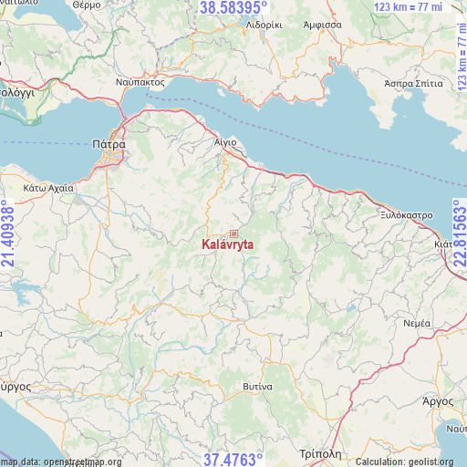
Kalávryta GPS coordinates[2]
38° 1' 55.992" North, 22° 6' 45" East
| Map corner | latitude | longitude |
|---|---|---|
| Upper-left | 38.58395°, | 21.40938° |
| Center: | 38.03222°, | 22.1125° |
| Lower-right: | 37.4763°, | 22.81563° |
| Map W x H: | 123.2×123.2 km | = 76.6×76.6mi |
| max Lat: | 41.72048° ⇑72.2% North |
| Kalávryta: | 38.03222° |
| min Lat: | ⇓27.8% South 34.8346° |
| min Long | Kalávryta | max Long |
| 19.40494° | 22.1125° | 29.59361° |
| W 30.4%⇐ | ⇒69.6% E |
Elevation
Elevation of Kalávryta is 732 m = 2402 ft, and this is 563.1 m = 1847 ft above average elevation for this country.
| Max E: |
1439 m = 4721 ft | 3.7% |
| Kalávryta | 732 m 2402 ft | |
| Avg. | 168.9 m = 554 ft | |
Min E: |
0 m = 0 ft | 96.3% |
See also: Greece elevation on elevation.city.
Geographical zone
Kalávryta is located in North temperate zone (between Tropic of Cancer and the Arctic Circle). Distance of this Northern Tropic circle is 1622.9 km =1008.4 mi to South.| Distance of | km | miles | from Kalávryta |
|---|---|---|---|
| North Pole | 5778.3 | 3590.5 | to North |
| Arctic Circle | 3172.4 | 1971.2 | to North |
| Tropic Cancer | 1622.9 | 1008.4 | to South |
| Equator | 4228.8 | 2627.7 | to South |


Nearby cities:
15 places around Kalávryta: (largest is in red/bold)
• Akráta
22.6 km =14 mi,  52°
52°
• Aígio
24.2 km =15 mi,  353°
353°
• Aíyira
24.8 km =15.4 mi,  58°
58°
• Chalandrítsa
30 km =18.6 mi,  286°
286°
• Dhervéni
29.1 km =18.1 mi,  67°
67°
• Kamárai
31.3 km =19.4 mi,  341°
341°
• Kandíla
37.2 km =23.1 mi,  140°
140°
• Likoporiá
36.1 km =22.4 mi, 72°
• Lóngos
30.3 km =18.8 mi, 344°
• Rododáfni
27 km =16.8 mi, 348°
• Rozená
26.8 km =16.7 mi, 68°
• Selianítika
28.7 km =17.8 mi, 345°
• Sylivainiótika
24 km =14.9 mi, 53°
• Témeni
22.8 km =14.2 mi,  2°
2°
• Áno Kastrítsi
36 km =22.4 mi,  317°
317°
Sources, notices
• [Note1] Compared only with cities in Greece existing in our database
• [Src1] Map data: © OpenStreetMap contributors (CC-BY-SA)
• [Src2] Other city data from geonames.org with taken over terms of usage.
• [Src3] Geographical zone / Annual Mean Temperature by Robert A. Rohde @ Wikipedia
