Magoúla geodata
Magoúla (Thessaly) is a populated place; located in Greece in Europe/Athens (GMT+3) time zone. With population of 1,036 people, there are 976 cities with bigger population in this country. Compared to other cities in Greece, 55.2% of cities are located further ↓South; 76.2% of cities are located further →East and 56.2% of cities have lower elevation than Magoúla. Note1


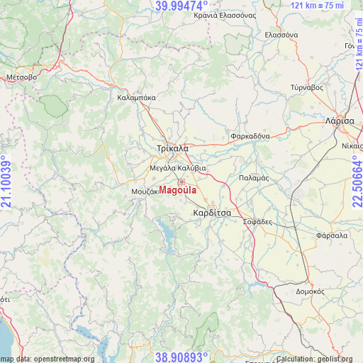
Magoúla GPS coordinates[2]
39° 27' 14.22" North, 21° 48' 12.636" East
| Map corner | latitude | longitude |
|---|---|---|
| Upper-left | 39.99474°, | 21.10039° |
| Center: | 39.45395°, | 21.80351° |
| Lower-right: | 38.90893°, | 22.50664° |
| Map W x H: | 120.7×120.7 km | = 75×75mi |
| max Lat: | 41.72048° ⇑44.8% North |
| Magoúla: | 39.45395° |
| min Lat: | ⇓55.2% South 34.8346° |
| min Long | Magoúla | max Long |
| 19.40494° | 21.80351° | 29.59361° |
| W 23.8%⇐ | ⇒76.2% E |
Elevation
Elevation of Magoúla is 102 m = 335 ft, and this is 66.9 m = 219 ft below average elevation for this country.
| Max E: |
1439 m = 4721 ft | 43.8% |
| Avg. | 168.9 m = 554 ft | |
| Magoúla | 102 m = 335 ft | |
Min E: |
0 m = 0 ft | 56.2% |
See also: Greece elevation on elevation.city.
Geographical zone
Magoúla is located in North temperate zone (between Tropic of Cancer and the Arctic Circle). Distance of this Northern Tropic circle is 1780.9 km =1106.6 mi to South.| Distance of | km | miles | from Magoúla |
|---|---|---|---|
| North Pole | 5620.2 | 3492.2 | to North |
| Arctic Circle | 3014.3 | 1873 | to North |
| Tropic Cancer | 1780.9 | 1106.6 | to South |
| Equator | 4386.9 | 2725.9 | to South |


Nearby cities:
15 places around Magoúla: (largest is in red/bold)
• Agnanteró
5.2 km =3.2 mi,  47°
47°
• Agía Triáda
8.2 km =5.1 mi,  82°
82°
• Droseró
8.2 km =5.1 mi,  319°
319°
• Fanári
4.3 km =2.7 mi,  185°
185°
• Gelánthi
8.5 km =5.3 mi,  258°
258°
• Glínos
8.3 km =5.2 mi,  39°
39°
• Kalogrianá
6.1 km =3.8 mi, 78°
• Kanália
6.2 km =3.9 mi,  183°
183°
• Kraniá
2.8 km =1.7 mi,  108°
108°
• Lazarína
5.7 km =3.5 mi,  279°
279°
• Magoulítsa
4.1 km =2.5 mi,  246°
246°
• Megála Kalývia
5 km =3.1 mi,  344°
344°
• Mouriá
8.3 km =5.2 mi,  297°
297°
• Palaiochóri
2.5 km =1.6 mi, 46°
• Rizovoúni
5.7 km =3.5 mi, 107°
Sources, notices
• [Note1] Compared only with cities in Greece existing in our database
• [Src1] Map data: © OpenStreetMap contributors (CC-BY-SA)
• [Src2] Other city data from geonames.org with taken over terms of usage.
• [Src3] Geographical zone / Annual Mean Temperature by Robert A. Rohde @ Wikipedia
