Droseró geodata
Droseró (Thessaly) is a populated place; located in Greece in Europe/Athens (GMT+3) time zone. With population of 523 people, there are 1759 cities with bigger population in this country. Compared to other cities in Greece, 56.8% of cities are located further ↓South; 77.5% of cities are located further →East and 58.4% of cities have lower elevation than Droseró. Note1


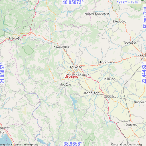
Droseró GPS coordinates[2]
39° 30' 37.368" North, 21° 44' 30.084" East
| Map corner | latitude | longitude |
|---|---|---|
| Upper-left | 40.05073°, | 21.03857° |
| Center: | 39.51038°, | 21.74169° |
| Lower-right: | 38.9658°, | 22.44482° |
| Map W x H: | 120.6×120.6 km | = 74.9×74.9mi |
| max Lat: | 41.72048° ⇑43.2% North |
| Droseró: | 39.51038° |
| min Lat: | ⇓56.8% South 34.8346° |
| min Long | Droseró | max Long |
| 19.40494° | 21.74169° | 29.59361° |
| W 22.5%⇐ | ⇒77.5% E |
Elevation
Elevation of Droseró is 111 m = 364 ft, and this is 57.9 m = 190 ft below average elevation for this country.
| Max E: |
1439 m = 4721 ft | 41.6% |
| Avg. | 168.9 m = 554 ft | |
| Droseró | 111 m = 364 ft | |
Min E: |
0 m = 0 ft | 58.4% |
See also: Greece elevation on elevation.city.
Geographical zone
Droseró is located in North temperate zone (between Tropic of Cancer and the Arctic Circle). Distance of this Northern Tropic circle is 1787.2 km =1110.5 mi to South.| Distance of | km | miles | from Droseró |
|---|---|---|---|
| North Pole | 5613.9 | 3488.3 | to North |
| Arctic Circle | 3008 | 1869.1 | to North |
| Tropic Cancer | 1787.2 | 1110.5 | to South |
| Equator | 4393.1 | 2729.7 | to South |


Nearby cities:
15 places around Droseró: (largest is in red/bold)
• Flamoúli
2.8 km =1.7 mi,  49°
49°
• Fíki
7.4 km =4.6 mi,  274°
274°
• Gómfoi
6.6 km =4.1 mi,  218°
218°
• Lazarína
5.3 km =3.3 mi,  183°
183°
• Lygariá
5.3 km =3.3 mi,  250°
250°
• Magoulítsa
8.1 km =5 mi,  168°
168°
• Magoúla
8.2 km =5.1 mi,  139°
139°
• Megála Kalývia
4.2 km =2.6 mi,  110°
110°
• Mouriá
3.2 km =2 mi, 221°
• Palaiochóri
8.4 km =5.2 mi,  122°
122°
• Pigí
3.5 km =2.2 mi, 270°
• Pyrgetós
4.7 km =2.9 mi,  7°
7°
• Rizarió
6 km =3.7 mi,  57°
57°
• Tríkala
5.5 km =3.4 mi,  24°
24°
• Valtinó
8.2 km =5.1 mi,  301°
301°
Sources, notices
• [Note1] Compared only with cities in Greece existing in our database
• [Src1] Map data: © OpenStreetMap contributors (CC-BY-SA)
• [Src2] Other city data from geonames.org with taken over terms of usage.
• [Src3] Geographical zone / Annual Mean Temperature by Robert A. Rohde @ Wikipedia
