Emporeío geodata
Emporeío (South Aegean) is a populated place; located in Greece in Europe/Athens (GMT+3) time zone. With population of 1,946 people, there are 535 cities with bigger population in this country. Compared to other cities in Greece, 93% of cities are located further ↑North; 90.6% of cities are located further ←West and 52.3% of cities have lower elevation than Emporeío. Note1


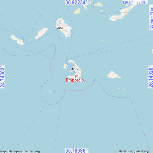
Emporeío GPS coordinates[2]
36° 21' 29.376" North, 25° 26' 46.14" East
| Map corner | latitude | longitude |
|---|---|---|
| Upper-left | 36.92234°, | 24.74303° |
| Center: | 36.35816°, | 25.44615° |
| Lower-right: | 35.78986°, | 26.14928° |
| Map W x H: | 125.9×125.9 km | = 78.2×78.2mi |
| max Lat: | 41.72048° ⇑93% North |
| Emporeío: | 36.35816° |
| min Lat: | ⇓7% South 34.8346° |
| min Long | Emporeío | max Long |
| 19.40494° | 25.44615° | 29.59361° |
| W 90.6%⇐ | ⇒9.4% E |
Elevation
Elevation of Emporeío is 90 m = 295 ft, and this is 78.9 m = 259 ft below average elevation for this country.
| Max E: |
1439 m = 4721 ft | 47.7% |
| Avg. | 168.9 m = 554 ft | |
| Emporeío | 90 m = 295 ft | |
Min E: |
0 m = 0 ft | 52.3% |
See also: Greece elevation on elevation.city.
Geographical zone
Emporeío is located in North temperate zone (between Tropic of Cancer and the Arctic Circle). Distance of this Northern Tropic circle is 1436.7 km =892.7 mi to South.| Distance of | km | miles | from Emporeío |
|---|---|---|---|
| North Pole | 5964.4 | 3706.1 | to North |
| Arctic Circle | 3358.5 | 2086.9 | to North |
| Tropic Cancer | 1436.7 | 892.7 | to South |
| Equator | 4042.6 | 2512 | to South |


Nearby cities:
15 places around Emporeío: (largest is in red/bold)
• Amorgós
66.3 km =41.2 mi,  37°
37°
• Antíparos
82.4 km =51.2 mi,  336°
336°
• Anáfi
28.7 km =17.8 mi,  91°
91°
• Apérathos
79.6 km =49.5 mi,  4°
4°
• Filótion
77.3 km =48 mi, 3°
• Firá
7.1 km =4.4 mi,  348°
348°
• Folégandros
55.8 km =34.7 mi,  302°
302°
• Glinádo
79.4 km =49.3 mi,  357°
357°
• Mesariá
4.5 km =2.8 mi, 2°
• Náxos
83.3 km =51.8 mi, 355°
• Oía
13.2 km =8.2 mi,  331°
331°
• Síkinos
48.1 km =29.9 mi,  322°
322°
• Vívlos
77.9 km =48.4 mi, 357°
• Ágios Arsénios
78.3 km =48.7 mi, 356°
• Íos
44.2 km =27.5 mi, 340°
Sources, notices
• [Note1] Compared only with cities in Greece existing in our database
• [Src1] Map data: © OpenStreetMap contributors (CC-BY-SA)
• [Src2] Other city data from geonames.org with taken over terms of usage.
• [Src3] Geographical zone / Annual Mean Temperature by Robert A. Rohde @ Wikipedia
