Spárti geodata
Spárti (Peloponnese) is a seat of a second-order administrative division; located in Greece in Europe/Athens (GMT+3) time zone. With population of 16,239 people, there are 103 cities with bigger population in this country. Compared to other cities in Greece, 89.1% of cities are located further ↑North; 61.9% of cities are located further →East and 74.6% of cities have lower elevation than Spárti. Note1


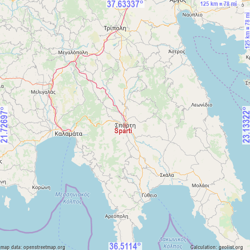
Spárti GPS coordinates[2]
37° 4' 28.056" North, 22° 25' 48.324" East
| Map corner | latitude | longitude |
|---|---|---|
| Upper-left | 37.63337°, | 21.72697° |
| Center: | 37.07446°, | 22.43009° |
| Lower-right: | 36.5114°, | 23.13322° |
| Map W x H: | 124.8×124.8 km | = 77.5×77.5mi |
| max Lat: | 41.72048° ⇑89.1% North |
| Spárti: | 37.07446° |
| min Lat: | ⇓10.9% South 34.8346° |
| min Long | Spárti | max Long |
| 19.40494° | 22.43009° | 29.59361° |
| W 38.1%⇐ | ⇒61.9% E |
Elevation
Elevation of Spárti is 206 m = 676 ft, and this is 37.1 m = 122 ft above average elevation for this country.
| Max E: |
1439 m = 4721 ft | 25.4% |
| Spárti | 206 m 676 ft | |
| Avg. | 168.9 m = 554 ft | |
Min E: |
0 m = 0 ft | 74.6% |
See also: Greece elevation on elevation.city.
Geographical zone
Spárti is located in North temperate zone (between Tropic of Cancer and the Arctic Circle). Distance of this Northern Tropic circle is 1516.4 km =942.2 mi to South.| Distance of | km | miles | from Spárti |
|---|---|---|---|
| North Pole | 5884.8 | 3656.6 | to North |
| Arctic Circle | 3278.9 | 2037.4 | to North |
| Tropic Cancer | 1516.4 | 942.2 | to South |
| Equator | 4122.3 | 2561.5 | to South |


Nearby cities:
15 places around Spárti: (largest is in red/bold)
• Asprókhoma
31.7 km =19.7 mi,  264°
264°
• Geráki
26.2 km =16.3 mi,  110°
110°
• Kalamata
28.4 km =17.6 mi, 262°
• Kardamýli
27.1 km =16.8 mi,  220°
220°
• Karyés
24.9 km =15.5 mi,  14°
14°
• Krokeés
23.7 km =14.7 mi,  154°
154°
• Laíika
29.7 km =18.5 mi,  267°
267°
• Magoúla
2.3 km =1.4 mi,  285°
285°
• Mikrá Mantíneia
26.5 km =16.5 mi,  248°
248°
• Paralía Vérgas
25.4 km =15.8 mi, 252°
• Skála
32.6 km =20.3 mi,  139°
139°
• Sperchógeia
32.6 km =20.3 mi, 269°
• Stoúpa
29.8 km =18.5 mi,  210°
210°
• Xirokámbion
12.9 km =8 mi,  171°
171°
• Ágios Pétros
30 km =18.6 mi,  20°
20°
Sources, notices
• [Note1] Compared only with cities in Greece existing in our database
• [Src1] Map data: © OpenStreetMap contributors (CC-BY-SA)
• [Src2] Other city data from geonames.org with taken over terms of usage.
• [Src3] Geographical zone / Annual Mean Temperature by Robert A. Rohde @ Wikipedia
