Lygariá geodata
Lygariá (Thessaly) is a populated place; located in Greece in Europe/Athens (GMT+3) time zone. With population of 580 people, there are 1623 cities with bigger population in this country. Compared to other cities in Greece, 56.2% of cities are located further ↓South; 78.9% of cities are located further →East and 65.5% of cities have lower elevation than Lygariá. Note1


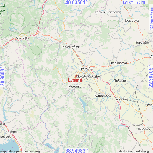
Lygariá GPS coordinates[2]
39° 29' 40.344" North, 21° 41' 2.112" East
| Map corner | latitude | longitude |
|---|---|---|
| Upper-left | 40.03501°, | 20.9808° |
| Center: | 39.49454°, | 21.68392° |
| Lower-right: | 38.94983°, | 22.38705° |
| Map W x H: | 120.7×120.7 km | = 75×75mi |
| max Lat: | 41.72048° ⇑43.8% North |
| Lygariá: | 39.49454° |
| min Lat: | ⇓56.2% South 34.8346° |
| min Long | Lygariá | max Long |
| 19.40494° | 21.68392° | 29.59361° |
| W 21.1%⇐ | ⇒78.9% E |
Elevation
Elevation of Lygariá is 142 m = 466 ft, and this is 26.9 m = 88 ft below average elevation for this country.
| Max E: |
1439 m = 4721 ft | 34.5% |
| Avg. | 168.9 m = 554 ft | |
| Lygariá | 142 m = 466 ft | |
Min E: |
0 m = 0 ft | 65.5% |
See also: Greece elevation on elevation.city.
Geographical zone
Lygariá is located in North temperate zone (between Tropic of Cancer and the Arctic Circle). Distance of this Northern Tropic circle is 1785.5 km =1109.5 mi to South.| Distance of | km | miles | from Lygariá |
|---|---|---|---|
| North Pole | 5615.7 | 3489.4 | to North |
| Arctic Circle | 3009.8 | 1870.2 | to North |
| Tropic Cancer | 1785.5 | 1109.5 | to South |
| Equator | 4391.4 | 2728.7 | to South |


Nearby cities:
15 places around Lygariá: (largest is in red/bold)
• Dendrochóri
7.6 km =4.7 mi,  328°
328°
• Droseró
5.3 km =3.3 mi,  70°
70°
• Eleftherochóri
5.6 km =3.5 mi,  310°
310°
• Fíki
3.4 km =2.1 mi, 314°
• Gelánthi
6.5 km =4 mi,  162°
162°
• Gómfoi
3.5 km =2.2 mi,  166°
166°
• Lazarína
5.9 km =3.7 mi,  127°
127°
• Mouriá
2.9 km =1.8 mi,  102°
102°
• Mouzáki
7.4 km =4.6 mi,  193°
193°
• Palaiomonástiro
4.2 km =2.6 mi,  212°
212°
• Pigí
2.3 km =1.4 mi,  39°
39°
• Piáleia
7.7 km =4.8 mi,  279°
279°
• Pýli
6.9 km =4.3 mi,  233°
233°
• Valtinó
6.3 km =3.9 mi,  341°
341°
• Ágios Vissaríonas
6.1 km =3.8 mi,  244°
244°
Sources, notices
• [Note1] Compared only with cities in Greece existing in our database
• [Src1] Map data: © OpenStreetMap contributors (CC-BY-SA)
• [Src2] Other city data from geonames.org with taken over terms of usage.
• [Src3] Geographical zone / Annual Mean Temperature by Robert A. Rohde @ Wikipedia
