Pigí geodata
Pigí (Thessaly) is a populated place; located in Greece in Europe/Athens (GMT+3) time zone. With population of 1,158 people, there are 860 cities with bigger population in this country. Compared to other cities in Greece, 56.8% of cities are located further ↓South; 78.5% of cities are located further →East and 60.8% of cities have lower elevation than Pigí. Note1


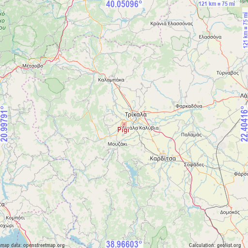
Pigí GPS coordinates[2]
39° 30' 38.196" North, 21° 42' 3.708" East
| Map corner | latitude | longitude |
|---|---|---|
| Upper-left | 40.05096°, | 20.99791° |
| Center: | 39.51061°, | 21.70103° |
| Lower-right: | 38.96603°, | 22.40416° |
| Map W x H: | 120.6×120.6 km | = 74.9×74.9mi |
| max Lat: | 41.72048° ⇑43.2% North |
| Pigí: | 39.51061° |
| min Lat: | ⇓56.8% South 34.8346° |
| min Long | Pigí | max Long |
| 19.40494° | 21.70103° | 29.59361° |
| W 21.5%⇐ | ⇒78.5% E |
Elevation
Elevation of Pigí is 120 m = 394 ft, and this is 48.9 m = 160 ft below average elevation for this country.
| Max E: |
1439 m = 4721 ft | 39.2% |
| Avg. | 168.9 m = 554 ft | |
| Pigí | 120 m = 394 ft | |
Min E: |
0 m = 0 ft | 60.8% |
See also: Greece elevation on elevation.city.
Geographical zone
Pigí is located in North temperate zone (between Tropic of Cancer and the Arctic Circle). Distance of this Northern Tropic circle is 1787.2 km =1110.5 mi to South.| Distance of | km | miles | from Pigí |
|---|---|---|---|
| North Pole | 5613.9 | 3488.3 | to North |
| Arctic Circle | 3008 | 1869.1 | to North |
| Tropic Cancer | 1787.2 | 1110.5 | to South |
| Equator | 4393.2 | 2729.8 | to South |


Nearby cities:
15 places around Pigí: (largest is in red/bold)
• Dendrochóri
7.2 km =4.5 mi,  310°
310°
• Droseró
3.5 km =2.2 mi,  90°
90°
• Eleftherochóri
6 km =3.7 mi,  288°
288°
• Flamoúli
5.9 km =3.7 mi,  72°
72°
• Fíki
3.9 km =2.4 mi,  278°
278°
• Gómfoi
5.2 km =3.2 mi,  187°
187°
• Kefalóvryso
7.9 km =4.9 mi,  354°
354°
• Lazarína
6.2 km =3.9 mi,  149°
149°
• Lygariá
2.3 km =1.4 mi,  219°
219°
• Megála Kalývia
7.6 km =4.7 mi,  101°
101°
• Mouriá
2.8 km =1.7 mi, 149°
• Palaiomonástiro
6.5 km =4 mi,  214°
214°
• Pyrgetós
6.2 km =3.9 mi,  40°
40°
• Tríkala
7.6 km =4.7 mi,  49°
49°
• Valtinó
5.5 km =3.4 mi,  320°
320°
Sources, notices
• [Note1] Compared only with cities in Greece existing in our database
• [Src1] Map data: © OpenStreetMap contributors (CC-BY-SA)
• [Src2] Other city data from geonames.org with taken over terms of usage.
• [Src3] Geographical zone / Annual Mean Temperature by Robert A. Rohde @ Wikipedia
