Valtinó geodata
Valtinó (Thessaly) is a populated place; located in Greece in Europe/Athens (GMT+3) time zone. With population of 780 people, there are 1294 cities with bigger population in this country. Compared to other cities in Greece, 57.7% of cities are located further ↓South; 79.5% of cities are located further →East and 60.2% of cities have lower elevation than Valtinó. Note1


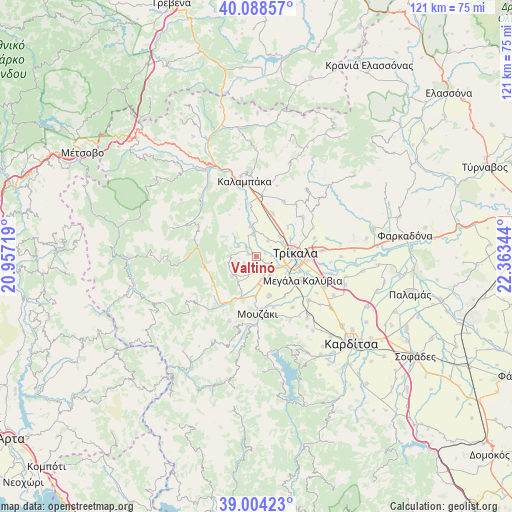
Valtinó GPS coordinates[2]
39° 32' 54.672" North, 21° 39' 37.116" East
| Map corner | latitude | longitude |
|---|---|---|
| Upper-left | 40.08857°, | 20.95719° |
| Center: | 39.54852°, | 21.66031° |
| Lower-right: | 39.00423°, | 22.36344° |
| Map W x H: | 120.6×120.6 km | = 74.9×74.9mi |
| max Lat: | 41.72048° ⇑42.3% North |
| Valtinó: | 39.54852° |
| min Lat: | ⇓57.7% South 34.8346° |
| min Long | Valtinó | max Long |
| 19.40494° | 21.66031° | 29.59361° |
| W 20.5%⇐ | ⇒79.5% E |
Elevation
Elevation of Valtinó is 118 m = 387 ft, and this is 50.9 m = 167 ft below average elevation for this country.
| Max E: |
1439 m = 4721 ft | 39.8% |
| Avg. | 168.9 m = 554 ft | |
| Valtinó | 118 m = 387 ft | |
Min E: |
0 m = 0 ft | 60.2% |
See also: Greece elevation on elevation.city.
Geographical zone
Valtinó is located in North temperate zone (between Tropic of Cancer and the Arctic Circle). Distance of this Northern Tropic circle is 1791.5 km =1113.2 mi to South.| Distance of | km | miles | from Valtinó |
|---|---|---|---|
| North Pole | 5609.7 | 3485.7 | to North |
| Arctic Circle | 3003.8 | 1866.5 | to North |
| Tropic Cancer | 1791.5 | 1113.2 | to South |
| Equator | 4397.4 | 2732.4 | to South |


Nearby cities:
15 places around Valtinó: (largest is in red/bold)
• Dendrochóri
2 km =1.2 mi,  283°
283°
• Dialektó
5.2 km =3.2 mi,  352°
352°
• Droseró
8.2 km =5.1 mi,  121°
121°
• Eleftherochóri
3.2 km =2 mi,  223°
223°
• Fíki
3.6 km =2.2 mi,  186°
186°
• Gorgogýri
6.2 km =3.9 mi,  268°
268°
• Kefalóvryso
4.6 km =2.9 mi,  37°
37°
• Lygariá
6.3 km =3.9 mi,  161°
161°
• Megárchis
7.1 km =4.4 mi, 348°
• Méga Kefalóvryso
7.4 km =4.6 mi,  52°
52°
• Pigí
5.5 km =3.4 mi,  140°
140°
• Piáleia
7.3 km =4.5 mi,  229°
229°
• Prínos
4.8 km =3 mi,  299°
299°
• Pródromos
6.3 km =3.9 mi,  286°
286°
• Pyrgetós
7.6 km =4.7 mi,  86°
86°
Sources, notices
• [Note1] Compared only with cities in Greece existing in our database
• [Src1] Map data: © OpenStreetMap contributors (CC-BY-SA)
• [Src2] Other city data from geonames.org with taken over terms of usage.
• [Src3] Geographical zone / Annual Mean Temperature by Robert A. Rohde @ Wikipedia
