Amfíkleia geodata
Amfíkleia (Central Greece) is a populated place; located in Greece in Europe/Athens (GMT+3) time zone. With population of 3,012 people, there are 348 cities with bigger population in this country. Compared to other cities in Greece, 59.1% of cities are located further ↑North; 57.2% of cities are located further →East and 85.6% of cities have lower elevation than Amfíkleia. Note1
Administrative division(s):
- Level 1: Central Greece
- Level 2: Nomós Fthiótidos
- Level 3: Dimos Amfikleia-Elateia


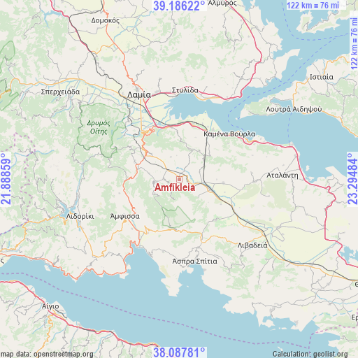
Amfíkleia GPS coordinates[2]
38° 38' 20.832" North, 22° 35' 30.156" East
| Map corner | latitude | longitude |
|---|---|---|
| Upper-left | 39.18622°, | 21.88859° |
| Center: | 38.63912°, | 22.59171° |
| Lower-right: | 38.08781°, | 23.29484° |
| Map W x H: | 122.1×122.1 km | = 75.9×75.9mi |
| max Lat: | 41.72048° ⇑59.1% North |
| Amfíkleia: | 38.63912° |
| min Lat: | ⇓40.9% South 34.8346° |
| min Long | Amfíkleia | max Long |
| 19.40494° | 22.59171° | 29.59361° |
| W 42.8%⇐ | ⇒57.2% E |
Elevation
Elevation of Amfíkleia is 389 m = 1276 ft, and this is 220.1 m = 722 ft above average elevation for this country.
| Max E: |
1439 m = 4721 ft | 14.4% |
| Amfíkleia | 389 m 1276 ft | |
| Avg. | 168.9 m = 554 ft | |
Min E: |
0 m = 0 ft | 85.6% |
See also: Greece elevation on elevation.city.
Geographical zone
Amfíkleia is located in North temperate zone (between Tropic of Cancer and the Arctic Circle). Distance of this Northern Tropic circle is 1690.3 km =1050.3 mi to South.| Distance of | km | miles | from Amfíkleia |
|---|---|---|---|
| North Pole | 5710.8 | 3548.5 | to North |
| Arctic Circle | 3104.9 | 1929.3 | to North |
| Tropic Cancer | 1690.3 | 1050.3 | to South |
| Equator | 4296.3 | 2669.6 | to South |


Nearby cities:
15 places around Amfíkleia: (largest is in red/bold)
• Anthíli
25.4 km =15.8 mi,  337°
337°
• Aráchova
17.8 km =11.1 mi,  182°
182°
• Delphi
19.7 km =12.2 mi,  205°
205°
• Dístomo
24.3 km =15.1 mi,  164°
164°
• Eláteia
15.1 km =9.4 mi,  94°
94°
• Kainoúryion
20.6 km =12.8 mi,  34°
34°
• Kaména Voúrla
22.9 km =14.2 mi,  47°
47°
• Káto Tithoréa
11.1 km =6.9 mi,  108°
108°
• Moskhokhórion
24.4 km =15.2 mi,  329°
329°
• Mólos
19.6 km =12.2 mi,  13°
13°
• Rengínion
13.6 km =8.5 mi, 48°
• Tithoréa
9 km =5.6 mi,  132°
132°
• Zéli
24.7 km =15.3 mi,  84°
84°
• Ámfissa
22.4 km =13.9 mi,  236°
236°
• Áyios Serafím
20.5 km =12.7 mi, 28°
Sources, notices
• [Note1] Compared only with cities in Greece existing in our database
• [Src1] Map data: © OpenStreetMap contributors (CC-BY-SA)
• [Src2] Other city data from geonames.org with taken over terms of usage.
• [Src3] Geographical zone / Annual Mean Temperature by Robert A. Rohde @ Wikipedia
