Stavrós geodata
Stavrós (Central Macedonia) is a seat of a third-order administrative division; located in Greece in Europe/Athens (GMT+3) time zone. In our database, there are 1823 cities with bigger population. Compared to other cities in Greece, 80.2% of cities are located further ↓South; 70.1% of cities are located further ←West and 97.4% of cities have higher elevation than Stavrós. Note1
Administrative division(s):
- Level 1: Central Macedonia
- Level 2: Nomós Thessaloníkis
- Level 3: Dimos Volvi


Stavrós GPS coordinates[2]
40° 39' 53.928" North, 23° 42' 0.54" East
| Map corner | latitude | longitude |
|---|---|---|
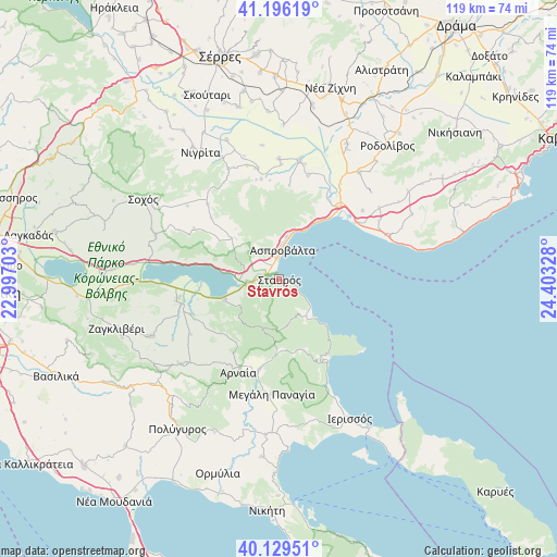
| Upper-left | 41.19619°, | 22.99703° |
| Center: | 40.66498°, | 23.70015° |
| Lower-right: | 40.12951°, | 24.40328° |
| Map W x H: | 118.6×118.6 km | = 73.7×73.7mi |
| max Lat: | 41.72048° ⇑19.8% North |
| Stavrós: | 40.66498° |
| min Lat: | ⇓80.2% South 34.8346° |
| min Long | Stavrós | max Long |
| 19.40494° | 23.70015° | 29.59361° |
| W 70.1%⇐ | ⇒29.9% E |
Elevation
Elevation of Stavrós is 4 m = 13 ft, and this is 164.9 m = 541 ft below average elevation for this country.
| Max E: |
1439 m = 4721 ft | 97.4% |
| Avg. | 168.9 m = 554 ft | |
| Stavrós | 4 m = 13 ft | |
Min E: |
0 m = 0 ft | 2.6% |
See also: Greece elevation on elevation.city.
Geographical zone
Stavrós is located in North temperate zone (between Tropic of Cancer and the Arctic Circle). Distance of this Northern Tropic circle is 1915.6 km =1190.3 mi to South.| Distance of | km | miles | from Stavrós |
|---|---|---|---|
| North Pole | 5485.5 | 3408.5 | to North |
| Arctic Circle | 2879.7 | 1789.4 | to North |
| Tropic Cancer | 1915.6 | 1190.3 | to South |
| Equator | 4521.5 | 2809.5 | to South |


Nearby cities:
15 places around Stavrós: (largest is in red/bold)
• Arnaía
21.7 km =13.5 mi,  204°
204°
• Aréthousa
12.9 km =8 mi,  312°
312°
• Asproválta
7.3 km =4.5 mi,  7°
7°
• Efkarpía
22.8 km =14.2 mi,  15°
15°
• Neochóri
17.5 km =10.9 mi,  185°
185°
• Néa Apollonía
22.3 km =13.9 mi,  258°
258°
• Néa Kerdýlia
18.7 km =11.6 mi,  39°
39°
• Néa Vrasná
4.6 km =2.9 mi,  358°
358°
• Olympiáda
10.7 km =6.6 mi,  139°
139°
• Palaiochóri
19.7 km =12.2 mi, 192°
• Paralía Ofryníou
20.3 km =12.6 mi,  56°
56°
• Stanós
16.3 km =10.1 mi,  214°
214°
• Stratoníki
16.2 km =10.1 mi,  160°
160°
• Stratónion
19.8 km =12.3 mi,  147°
147°
• Varvára
11.2 km =7 mi, 198°
Sources, notices
• [Note1] Compared only with cities in Greece existing in our database
• [Src1] Map data: © OpenStreetMap contributors (CC-BY-SA)
• [Src2] Other city data from geonames.org with taken over terms of usage.
• [Src3] Geographical zone / Annual Mean Temperature by Robert A. Rohde @ Wikipedia
