Neochóri geodata
Neochóri (Central Macedonia) is a populated place; located in Greece in Europe/Athens (GMT+3) time zone. With population of 714 people, there are 1396 cities with bigger population in this country. Compared to other cities in Greece, 75.2% of cities are located further ↓South; 69.1% of cities are located further ←West and 91.6% of cities have lower elevation than Neochóri. Note1
Administrative division(s):
- Level 1: Central Macedonia
- Level 2: Nomós Chalkidikís
- Level 3: Dimos Aristotelis


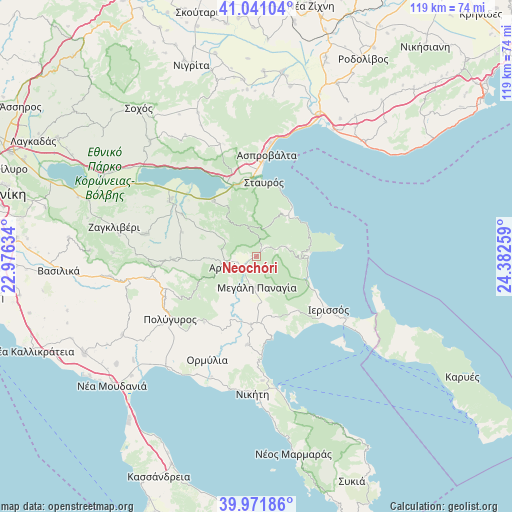
Neochóri GPS coordinates[2]
40° 30' 30.888" North, 23° 40' 46.056" East
| Map corner | latitude | longitude |
|---|---|---|
| Upper-left | 41.04104°, | 22.97634° |
| Center: | 40.50858°, | 23.67946° |
| Lower-right: | 39.97186°, | 24.38259° |
| Map W x H: | 118.9×118.9 km | = 73.9×73.9mi |
| max Lat: | 41.72048° ⇑24.8% North |
| Neochóri: | 40.50858° |
| min Lat: | ⇓75.2% South 34.8346° |
| min Long | Neochóri | max Long |
| 19.40494° | 23.67946° | 29.59361° |
| W 69.1%⇐ | ⇒30.9% E |
Elevation
Elevation of Neochóri is 556 m = 1824 ft, and this is 387.1 m = 1270 ft above average elevation for this country.
| Max E: |
1439 m = 4721 ft | 8.4% |
| Neochóri | 556 m 1824 ft | |
| Avg. | 168.9 m = 554 ft | |
Min E: |
0 m = 0 ft | 91.6% |
See also: Greece elevation on elevation.city.
Geographical zone
Neochóri is located in North temperate zone (between Tropic of Cancer and the Arctic Circle). Distance of this Northern Tropic circle is 1898.2 km =1179.5 mi to South.| Distance of | km | miles | from Neochóri |
|---|---|---|---|
| North Pole | 5502.9 | 3419.3 | to North |
| Arctic Circle | 2897 | 1800.1 | to North |
| Tropic Cancer | 1898.2 | 1179.5 | to South |
| Equator | 4504.1 | 2798.7 | to South |


Nearby cities:
15 places around Neochóri: (largest is in red/bold)
• Arnaía
7.5 km =4.7 mi,  250°
250°
• Gomáti
15.9 km =9.9 mi,  141°
141°
• Ierissós
20.7 km =12.9 mi,  126°
126°
• Megáli Panagía
7.1 km =4.4 mi,  179°
179°
• Metagkítsi
20.6 km =12.8 mi,  185°
185°
• Olympiáda
12.7 km =7.9 mi,  43°
43°
• Palaiochóra
19.3 km =12 mi,  267°
267°
• Palaiochóri
3.2 km =2 mi,  233°
233°
• Stanós
8.6 km =5.3 mi,  297°
297°
• Stavrós
17.5 km =10.9 mi,  5°
5°
• Stratoníki
7.4 km =4.6 mi,  73°
73°
• Stratónion
12.3 km =7.6 mi,  87°
87°
• Taxiárchis
16.2 km =10.1 mi,  235°
235°
• Varvára
7 km =4.3 mi,  345°
345°
• Vrástama
19.5 km =12.1 mi,  218°
218°
Sources, notices
• [Note1] Compared only with cities in Greece existing in our database
• [Src1] Map data: © OpenStreetMap contributors (CC-BY-SA)
• [Src2] Other city data from geonames.org with taken over terms of usage.
• [Src3] Geographical zone / Annual Mean Temperature by Robert A. Rohde @ Wikipedia
