Varvára geodata
Varvára (Central Macedonia) is a populated place; located in Greece in Europe/Athens (GMT+3) time zone. With population of 538 people, there are 1722 cities with bigger population in this country. Compared to other cities in Greece, 76.7% of cities are located further ↓South; 68.5% of cities are located further ←West and 91.3% of cities have lower elevation than Varvára. Note1
Administrative division(s):
- Level 1: Central Macedonia
- Level 2: Nomós Chalkidikís
- Level 3: Dimos Aristotelis


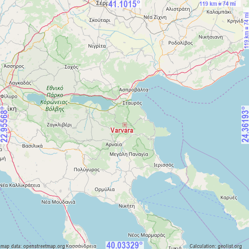
Varvára GPS coordinates[2]
40° 34' 10.308" North, 23° 39' 31.68" East
| Map corner | latitude | longitude |
|---|---|---|
| Upper-left | 41.1015°, | 22.95568° |
| Center: | 40.56953°, | 23.6588° |
| Lower-right: | 40.03329°, | 24.36193° |
| Map W x H: | 118.8×118.8 km | = 73.8×73.8mi |
| max Lat: | 41.72048° ⇑23.3% North |
| Varvára: | 40.56953° |
| min Lat: | ⇓76.7% South 34.8346° |
| min Long | Varvára | max Long |
| 19.40494° | 23.6588° | 29.59361° |
| W 68.5%⇐ | ⇒31.5% E |
Elevation
Elevation of Varvára is 545 m = 1788 ft, and this is 376.1 m = 1234 ft above average elevation for this country.
| Max E: |
1439 m = 4721 ft | 8.7% |
| Varvára | 545 m 1788 ft | |
| Avg. | 168.9 m = 554 ft | |
Min E: |
0 m = 0 ft | 91.3% |
See also: Greece elevation on elevation.city.
Geographical zone
Varvára is located in North temperate zone (between Tropic of Cancer and the Arctic Circle). Distance of this Northern Tropic circle is 1905 km =1183.7 mi to South.| Distance of | km | miles | from Varvára |
|---|---|---|---|
| North Pole | 5496.2 | 3415.2 | to North |
| Arctic Circle | 2890.3 | 1795.9 | to North |
| Tropic Cancer | 1905 | 1183.7 | to South |
| Equator | 4510.9 | 2802.9 | to South |


Nearby cities:
15 places around Varvára: (largest is in red/bold)
• Arnaía
10.7 km =6.6 mi,  210°
210°
• Aréthousa
20.3 km =12.6 mi,  342°
342°
• Asproválta
18.4 km =11.4 mi,  14°
14°
• Megáli Panagía
14 km =8.7 mi,  172°
172°
• Neochóri
7 km =4.3 mi, 165°
• Néa Apollonía
19.4 km =12.1 mi,  288°
288°
• Néa Vrasná
15.5 km =9.6 mi, 12°
• Olympiáda
10.7 km =6.6 mi,  76°
76°
• Palaiochóra
19.1 km =11.9 mi,  246°
246°
• Palaiochóri
8.7 km =5.4 mi,  185°
185°
• Stanós
6.4 km =4 mi,  244°
244°
• Stavrós
11.2 km =7 mi,  18°
18°
• Stratoníki
10 km =6.2 mi,  117°
117°
• Stratónion
15.3 km =9.5 mi,  113°
113°
• Taxiárchis
19.8 km =12.3 mi,  215°
215°
Sources, notices
• [Note1] Compared only with cities in Greece existing in our database
• [Src1] Map data: © OpenStreetMap contributors (CC-BY-SA)
• [Src2] Other city data from geonames.org with taken over terms of usage.
• [Src3] Geographical zone / Annual Mean Temperature by Robert A. Rohde @ Wikipedia
