Leptokaryá geodata
Leptokaryá (Central Macedonia) is a populated place; located in Greece in Europe/Athens (GMT+3) time zone. With population of 3,366 people, there are 319 cities with bigger population in this country. Compared to other cities in Greece, 67.3% of cities are located further ↓South; 58.1% of cities are located further →East and 71.4% of cities have higher elevation than Leptokaryá. Note1
Administrative division(s):
- Level 1: Central Macedonia
- Level 2: Nomós Pierías
- Level 3: Dimos Dio-Olympos


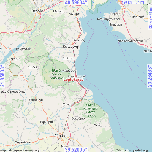
Leptokaryá GPS coordinates[2]
40° 3' 37.152" North, 22° 33' 40.32" East
| Map corner | latitude | longitude |
|---|---|---|
| Upper-left | 40.59634°, | 21.85808° |
| Center: | 40.06032°, | 22.5612° |
| Lower-right: | 39.52005°, | 23.26433° |
| Map W x H: | 119.7×119.7 km | = 74.4×74.4mi |
| max Lat: | 41.72048° ⇑32.7% North |
| Leptokaryá: | 40.06032° |
| min Lat: | ⇓67.3% South 34.8346° |
| min Long | Leptokaryá | max Long |
| 19.40494° | 22.5612° | 29.59361° |
| W 41.9%⇐ | ⇒58.1% E |
Elevation
Elevation of Leptokaryá is 29 m = 95 ft, and this is 139.9 m = 459 ft below average elevation for this country.
| Max E: |
1439 m = 4721 ft | 71.4% |
| Avg. | 168.9 m = 554 ft | |
| Leptokaryá | 29 m = 95 ft | |
Min E: |
0 m = 0 ft | 28.6% |
See also: Greece elevation on elevation.city.
Geographical zone
Leptokaryá is located in North temperate zone (between Tropic of Cancer and the Arctic Circle). Distance of this Northern Tropic circle is 1848.4 km =1148.5 mi to South.| Distance of | km | miles | from Leptokaryá |
|---|---|---|---|
| North Pole | 5552.8 | 3450.3 | to North |
| Arctic Circle | 2946.9 | 1831.1 | to North |
| Tropic Cancer | 1848.4 | 1148.5 | to South |
| Equator | 4454.3 | 2767.8 | to South |


Nearby cities:
15 places around Leptokaryá: (largest is in red/bold)
• Aigáni
12.7 km =7.9 mi,  160°
160°
• Díon
14 km =8.7 mi,  332°
332°
• Gónnoi
23.3 km =14.5 mi,  198°
198°
• Karítsa
15.7 km =9.8 mi, 334°
• Kontariótissa
20.5 km =12.7 mi,  335°
335°
• Litóchoro
7 km =4.3 mi,  309°
309°
• Néa Éfesos
19.5 km =12.1 mi, 344°
• Néoi Póroi
11.9 km =7.4 mi,  140°
140°
• Omólio
19.6 km =12.2 mi, 159°
• Paralía
23.2 km =14.4 mi,  7°
7°
• Pyrgetós
16 km =9.9 mi,  170°
170°
• Rapsáni
17.6 km =10.9 mi,  183°
183°
• Skotína
5.1 km =3.2 mi,  188°
188°
• Vrontoú
18.4 km =11.4 mi,  323°
323°
• Ágios Spyrídon
19.2 km =11.9 mi, 328°
Sources, notices
• [Note1] Compared only with cities in Greece existing in our database
• [Src1] Map data: © OpenStreetMap contributors (CC-BY-SA)
• [Src2] Other city data from geonames.org with taken over terms of usage.
• [Src3] Geographical zone / Annual Mean Temperature by Robert A. Rohde @ Wikipedia
