Rodópoli geodata
Rodópoli (Central Macedonia) is a populated place; located in Greece in Europe/Athens (GMT+3) time zone. With population of 820 people, there are 1246 cities with bigger population in this country. Compared to other cities in Greece, 98.4% of cities are located further ↓South; 55% of cities are located further ←West and 54.8% of cities have lower elevation than Rodópoli. Note1


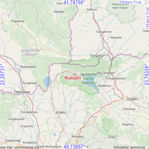
Rodópoli GPS coordinates[2]
41° 15' 40.5" North, 23° 0' 1.548" East
| Map corner | latitude | longitude |
|---|---|---|
| Upper-left | 41.78766°, | 22.29731° |
| Center: | 41.26125°, | 23.00043° |
| Lower-right: | 40.73057°, | 23.70356° |
| Map W x H: | 117.5×117.5 km | = 73×73mi |
| max Lat: | 41.72048° ⇑1.6% North |
| Rodópoli: | 41.26125° |
| min Lat: | ⇓98.4% South 34.8346° |
| min Long | Rodópoli | max Long |
| 19.40494° | 23.00043° | 29.59361° |
| W 55%⇐ | ⇒45% E |
Elevation
Elevation of Rodópoli is 98 m = 322 ft, and this is 70.9 m = 233 ft below average elevation for this country.
| Max E: |
1439 m = 4721 ft | 45.2% |
| Avg. | 168.9 m = 554 ft | |
| Rodópoli | 98 m = 322 ft | |
Min E: |
0 m = 0 ft | 54.8% |
See also: Greece elevation on elevation.city.
Geographical zone
Rodópoli is located in North temperate zone (between Tropic of Cancer and the Arctic Circle). Distance of this Northern Tropic circle is 1981.9 km =1231.5 mi to South.| Distance of | km | miles | from Rodópoli |
|---|---|---|---|
| North Pole | 5419.2 | 3367.3 | to North |
| Arctic Circle | 2813.4 | 1748.2 | to North |
| Tropic Cancer | 1981.9 | 1231.5 | to South |
| Equator | 4587.8 | 2850.7 | to South |


Nearby cities:
15 places around Rodópoli: (largest is in red/bold)
• Chrysochórafa
21.6 km =13.4 mi,  114°
114°
• Drosáto
19.6 km =12.2 mi,  237°
237°
• Efkarpía
22.2 km =13.8 mi,  200°
200°
• Kastanoússa
9.1 km =5.7 mi,  281°
281°
• Kerkíni
8.5 km =5.3 mi,  123°
123°
• Limnochóri
18.1 km =11.2 mi, 109°
• Lithótopos
23.3 km =14.5 mi,  127°
127°
• Livadiá
6.4 km =4 mi,  99°
99°
• Megalochóri
18.8 km =11.7 mi,  94°
94°
• Mouriés
17.1 km =10.6 mi,  267°
267°
• Myriófyto
15.1 km =9.4 mi,  253°
253°
• Pontisméno
24.4 km =15.2 mi, 103°
• Stathmós Mourión
13.5 km =8.4 mi, 271°
• Vyróneia
21.1 km =13.1 mi, 88°
• Áno Poróïa
4.1 km =2.5 mi,  48°
48°
Sources, notices
• [Note1] Compared only with cities in Greece existing in our database
• [Src1] Map data: © OpenStreetMap contributors (CC-BY-SA)
• [Src2] Other city data from geonames.org with taken over terms of usage.
• [Src3] Geographical zone / Annual Mean Temperature by Robert A. Rohde @ Wikipedia
