Megalochóri geodata
Megalochóri (Central Macedonia) is a populated place; located in Greece in Europe/Athens (GMT+3) time zone. With population of 658 people, there are 1485 cities with bigger population in this country. Compared to other cities in Greece, 98.2% of cities are located further ↓South; 59% of cities are located further ←West and 66.1% of cities have higher elevation than Megalochóri. Note1


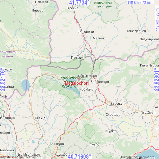
Megalochóri GPS coordinates[2]
41° 14' 48.768" North, 23° 13' 29.568" East
| Map corner | latitude | longitude |
|---|---|---|
| Upper-left | 41.7734°, | 22.52176° |
| Center: | 41.24688°, | 23.22488° |
| Lower-right: | 40.71608°, | 23.92801° |
| Map W x H: | 117.6×117.6 km | = 73.1×73.1mi |
| max Lat: | 41.72048° ⇑1.8% North |
| Megalochóri: | 41.24688° |
| min Lat: | ⇓98.2% South 34.8346° |
| min Long | Megalochóri | max Long |
| 19.40494° | 23.22488° | 29.59361° |
| W 59%⇐ | ⇒41% E |
Elevation
Elevation of Megalochóri is 37 m = 121 ft, and this is 131.9 m = 433 ft below average elevation for this country.
| Max E: |
1439 m = 4721 ft | 66.1% |
| Avg. | 168.9 m = 554 ft | |
| Megalochóri | 37 m = 121 ft | |
Min E: |
0 m = 0 ft | 33.9% |
See also: Greece elevation on elevation.city.
Geographical zone
Megalochóri is located in North temperate zone (between Tropic of Cancer and the Arctic Circle). Distance of this Northern Tropic circle is 1980.3 km =1230.5 mi to South.| Distance of | km | miles | from Megalochóri |
|---|---|---|---|
| North Pole | 5420.8 | 3368.3 | to North |
| Arctic Circle | 2815 | 1749.2 | to North |
| Tropic Cancer | 1980.3 | 1230.5 | to South |
| Equator | 4586.2 | 2849.7 | to South |


Nearby cities:
15 places around Megalochóri: (largest is in red/bold)
• Charopó
12.5 km =7.8 mi,  83°
83°
• Chorteró
12.4 km =7.7 mi,  104°
104°
• Chrysochórafa
7.4 km =4.6 mi,  173°
173°
• Dasochóri
10 km =6.2 mi,  158°
158°
• Irákleia
8.7 km =5.4 mi,  146°
146°
• Kerkíni
12.1 km =7.5 mi,  255°
255°
• Koímisi
7.4 km =4.6 mi,  120°
120°
• Limnochóri
4.9 km =3 mi,  200°
200°
• Lithótopos
12.5 km =7.8 mi,  181°
181°
• Livadiá
12.5 km =7.8 mi,  272°
272°
• Néo Petrítsi
6.5 km =4 mi,  61°
61°
• Pontisméno
6.5 km =4 mi,  130°
130°
• Sidirókastro
13.8 km =8.6 mi, 95°
• Valteró
11 km =6.8 mi, 133°
• Vyróneia
3.1 km =1.9 mi,  48°
48°
Sources, notices
• [Note1] Compared only with cities in Greece existing in our database
• [Src1] Map data: © OpenStreetMap contributors (CC-BY-SA)
• [Src2] Other city data from geonames.org with taken over terms of usage.
• [Src3] Geographical zone / Annual Mean Temperature by Robert A. Rohde @ Wikipedia
