Vyróneia geodata
Vyróneia (Central Macedonia) is a populated place; located in Greece in Europe/Athens (GMT+3) time zone. With population of 762 people, there are 1315 cities with bigger population in this country. Compared to other cities in Greece, 98.5% of cities are located further ↓South; 59.5% of cities are located further ←West and 59.2% of cities have higher elevation than Vyróneia. Note1


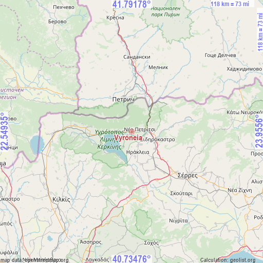
Vyróneia GPS coordinates[2]
41° 15' 55.476" North, 23° 15' 8.892" East
| Map corner | latitude | longitude |
|---|---|---|
| Upper-left | 41.79178°, | 22.54935° |
| Center: | 41.26541°, | 23.25247° |
| Lower-right: | 40.73476°, | 23.9556° |
| Map W x H: | 117.5×117.5 km | = 73×73mi |
| max Lat: | 41.72048° ⇑1.5% North |
| Vyróneia: | 41.26541° |
| min Lat: | ⇓98.5% South 34.8346° |
| min Long | Vyróneia | max Long |
| 19.40494° | 23.25247° | 29.59361° |
| W 59.5%⇐ | ⇒40.5% E |
Elevation
Elevation of Vyróneia is 52 m = 171 ft, and this is 116.9 m = 384 ft below average elevation for this country.
| Max E: |
1439 m = 4721 ft | 59.2% |
| Avg. | 168.9 m = 554 ft | |
| Vyróneia | 52 m = 171 ft | |
Min E: |
0 m = 0 ft | 40.8% |
See also: Greece elevation on elevation.city.
Geographical zone
Vyróneia is located in North temperate zone (between Tropic of Cancer and the Arctic Circle). Distance of this Northern Tropic circle is 1982.4 km =1231.8 mi to South.| Distance of | km | miles | from Vyróneia |
|---|---|---|---|
| North Pole | 5418.8 | 3367.1 | to North |
| Arctic Circle | 2812.9 | 1747.9 | to North |
| Tropic Cancer | 1982.4 | 1231.8 | to South |
| Equator | 4588.3 | 2851 | to South |


Nearby cities:
15 places around Vyróneia: (largest is in red/bold)
• Charopó
10.1 km =6.3 mi,  93°
93°
• Chorteró
11 km =6.8 mi,  117°
117°
• Chrysochórafa
9.5 km =5.9 mi,  188°
188°
• Dasochóri
11.4 km =7.1 mi,  173°
173°
• Gefyroúdi
14.9 km =9.3 mi,  142°
142°
• Irákleia
9.6 km =6 mi,  164°
164°
• Koímisi
7.1 km =4.4 mi,  145°
145°
• Limnochóri
7.7 km =4.8 mi,  211°
211°
• Lithótopos
14.8 km =9.2 mi, 190°
• Livadiá
14.8 km =9.2 mi,  264°
264°
• Megalochóri
3.1 km =1.9 mi,  228°
228°
• Néo Petrítsi
3.6 km =2.2 mi,  73°
73°
• Pontisméno
6.8 km =4.2 mi, 157°
• Sidirókastro
11.9 km =7.4 mi,  106°
106°
• Valteró
11.1 km =6.9 mi, 149°
Sources, notices
• [Note1] Compared only with cities in Greece existing in our database
• [Src1] Map data: © OpenStreetMap contributors (CC-BY-SA)
• [Src2] Other city data from geonames.org with taken over terms of usage.
• [Src3] Geographical zone / Annual Mean Temperature by Robert A. Rohde @ Wikipedia
