Kastanoússa geodata
Kastanoússa (Central Macedonia) is a populated place; located in Greece in Europe/Athens (GMT+3) time zone. With population of 592 people, there are 1600 cities with bigger population in this country. Compared to other cities in Greece, 98.8% of cities are located further ↓South; 51.6% of cities are located further ←West and 80.1% of cities have lower elevation than Kastanoússa. Note1


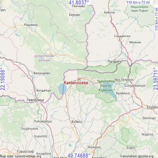
Kastanoússa GPS coordinates[2]
41° 16' 38.748" North, 22° 53' 38.328" East
| Map corner | latitude | longitude |
|---|---|---|
| Upper-left | 41.8037°, | 22.19086° |
| Center: | 41.27743°, | 22.89398° |
| Lower-right: | 40.74688°, | 23.59711° |
| Map W x H: | 117.5×117.5 km | = 73×73mi |
| max Lat: | 41.72048° ⇑1.2% North |
| Kastanoússa: | 41.27743° |
| min Lat: | ⇓98.8% South 34.8346° |
| min Long | Kastanoússa | max Long |
| 19.40494° | 22.89398° | 29.59361° |
| W 51.6%⇐ | ⇒48.4% E |
Elevation
Elevation of Kastanoússa is 279 m = 915 ft, and this is 110.1 m = 361 ft above average elevation for this country.
| Max E: |
1439 m = 4721 ft | 19.9% |
| Kastanoússa | 279 m 915 ft | |
| Avg. | 168.9 m = 554 ft | |
Min E: |
0 m = 0 ft | 80.1% |
See also: Greece elevation on elevation.city.
Geographical zone
Kastanoússa is located in North temperate zone (between Tropic of Cancer and the Arctic Circle). Distance of this Northern Tropic circle is 1983.7 km =1232.6 mi to South.| Distance of | km | miles | from Kastanoússa |
|---|---|---|---|
| North Pole | 5417.4 | 3366.2 | to North |
| Arctic Circle | 2811.6 | 1747 | to North |
| Tropic Cancer | 1983.7 | 1232.6 | to South |
| Equator | 4589.6 | 2851.8 | to South |


Nearby cities:
15 places around Kastanoússa: (largest is in red/bold)
• Chrysochórafa
30.5 km =19 mi,  110°
110°
• Chérso
23 km =14.3 mi,  204°
204°
• Drosáto
14.5 km =9 mi,  211°
211°
• Efkarpía
22.7 km =14.1 mi,  176°
176°
• Kerkíni
17.2 km =10.7 mi, 112°
• Limnochóri
27.2 km =16.9 mi, 107°
• Livadiá
15.5 km =9.6 mi,  100°
100°
• Megalochóri
27.9 km =17.3 mi, 97°
• Mouriés
8.6 km =5.3 mi,  251°
251°
• Myriófyto
8.2 km =5.1 mi,  222°
222°
• Pontoirákleia
29.8 km =18.5 mi,  229°
229°
• Rodópoli
9.1 km =5.7 mi, 101°
• Stathmós Mourión
4.9 km =3 mi, 251°
• Vyróneia
30 km =18.6 mi,  92°
92°
• Áno Poróïa
12 km =7.5 mi, 85°
Sources, notices
• [Note1] Compared only with cities in Greece existing in our database
• [Src1] Map data: © OpenStreetMap contributors (CC-BY-SA)
• [Src2] Other city data from geonames.org with taken over terms of usage.
• [Src3] Geographical zone / Annual Mean Temperature by Robert A. Rohde @ Wikipedia
