Lithótopos geodata
Lithótopos (Central Macedonia) is a populated place; located in Greece in Europe/Athens (GMT+3) time zone. With population of 692 people, there are 1424 cities with bigger population in this country. Compared to other cities in Greece, 96.3% of cities are located further ↓South; 59% of cities are located further ←West and 62.1% of cities have higher elevation than Lithótopos. Note1
Administrative division(s):
- Level 1: Central Macedonia
- Level 2: Nomós Serrón
- Level 3: Dimos Irakleia


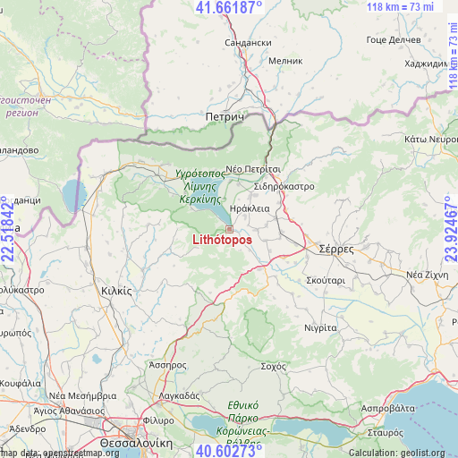
Lithótopos GPS coordinates[2]
41° 8' 3.984" North, 23° 13' 17.544" East
| Map corner | latitude | longitude |
|---|---|---|
| Upper-left | 41.66187°, | 22.51842° |
| Center: | 41.13444°, | 23.22154° |
| Lower-right: | 40.60273°, | 23.92467° |
| Map W x H: | 117.8×117.8 km | = 73.2×73.2mi |
| max Lat: | 41.72048° ⇑3.7% North |
| Lithótopos: | 41.13444° |
| min Lat: | ⇓96.3% South 34.8346° |
| min Long | Lithótopos | max Long |
| 19.40494° | 23.22154° | 29.59361° |
| W 59%⇐ | ⇒41% E |
Elevation
Elevation of Lithótopos is 45 m = 148 ft, and this is 123.9 m = 406 ft below average elevation for this country.
| Max E: |
1439 m = 4721 ft | 62.1% |
| Avg. | 168.9 m = 554 ft | |
| Lithótopos | 45 m = 148 ft | |
Min E: |
0 m = 0 ft | 37.9% |
See also: Greece elevation on elevation.city.
Geographical zone
Lithótopos is located in North temperate zone (between Tropic of Cancer and the Arctic Circle). Distance of this Northern Tropic circle is 1967.8 km =1222.7 mi to South.| Distance of | km | miles | from Lithótopos |
|---|---|---|---|
| North Pole | 5433.3 | 3376.1 | to North |
| Arctic Circle | 2827.5 | 1756.9 | to North |
| Tropic Cancer | 1967.8 | 1222.7 | to South |
| Equator | 4573.7 | 2842 | to South |


Nearby cities:
15 places around Lithótopos: (largest is in red/bold)
• Ammoudhiá
9.6 km =6 mi,  84°
84°
• Anayénnisis
9.7 km =6 mi,  106°
106°
• Cheímarros
4.1 km =2.5 mi,  130°
130°
• Chrysochórafa
5.3 km =3.3 mi,  12°
12°
• Dasochóri
5 km =3.1 mi,  50°
50°
• Gefyroúdi
12 km =7.5 mi, 76°
• Irákleia
7.4 km =4.6 mi,  43°
43°
• Karperí
6.9 km =4.3 mi,  92°
92°
• Koímisi
10.9 km =6.8 mi, 37°
• Limnochóri
8.1 km =5 mi,  349°
349°
• Megalochóri
12.5 km =7.8 mi,  1°
1°
• Pontisméno
9.8 km =6.1 mi,  31°
31°
• Strymonikó
13 km =8.1 mi,  142°
142°
• Valteró
9.6 km =6 mi,  58°
58°
• Vamvakiá
11.8 km =7.3 mi,  118°
118°
Sources, notices
• [Note1] Compared only with cities in Greece existing in our database
• [Src1] Map data: © OpenStreetMap contributors (CC-BY-SA)
• [Src2] Other city data from geonames.org with taken over terms of usage.
• [Src3] Geographical zone / Annual Mean Temperature by Robert A. Rohde @ Wikipedia
