Ptolemaḯda geodata
Ptolemaḯda (West Macedonia) is a seat of a third-order administrative division; located in Greece in Europe/Athens (GMT+3) time zone. With population of 30,045 people, there are 62 cities with bigger population in this country. Compared to other cities in Greece, 75.3% of cities are located further ↓South; 79.2% of cities are located further →East and 93.2% of cities have lower elevation than Ptolemaḯda. Note1


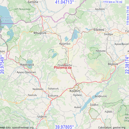
Ptolemaḯda GPS coordinates[2]
40° 30' 52.992" North, 21° 40' 42.996" East
| Map corner | latitude | longitude |
|---|---|---|
| Upper-left | 41.04713°, | 20.97549° |
| Center: | 40.51472°, | 21.67861° |
| Lower-right: | 39.97805°, | 22.38174° |
| Map W x H: | 118.9×118.9 km | = 73.9×73.9mi |
| max Lat: | 41.72048° ⇑24.7% North |
| Ptolemaḯda: | 40.51472° |
| min Lat: | ⇓75.3% South 34.8346° |
| min Long | Ptolemaḯda | max Long |
| 19.40494° | 21.67861° | 29.59361° |
| W 20.8%⇐ | ⇒79.2% E |
Elevation
Elevation of Ptolemaḯda is 609 m = 1998 ft, and this is 440.1 m = 1444 ft above average elevation for this country.
| Max E: |
1439 m = 4721 ft | 6.8% |
| Ptolemaḯda | 609 m 1998 ft | |
| Avg. | 168.9 m = 554 ft | |
Min E: |
0 m = 0 ft | 93.2% |
See also: Greece elevation on elevation.city.
Geographical zone
Ptolemaḯda is located in North temperate zone (between Tropic of Cancer and the Arctic Circle). Distance of this Northern Tropic circle is 1898.9 km =1179.9 mi to South.| Distance of | km | miles | from Ptolemaḯda |
|---|---|---|---|
| North Pole | 5502.2 | 3418.9 | to North |
| Arctic Circle | 2896.4 | 1799.7 | to North |
| Tropic Cancer | 1898.9 | 1179.9 | to South |
| Equator | 4504.8 | 2799.2 | to South |


Nearby cities:
15 places around Ptolemaḯda: (largest is in red/bold)
• Aetós
19.4 km =12.1 mi,  327°
327°
• Amýntaio
19.5 km =12.1 mi,  0°
0°
• Anaráchi
9.3 km =5.8 mi,  254°
254°
• Anatolikó
6.8 km =4.2 mi,  60°
60°
• Análipsi
20.3 km =12.6 mi, 1°
• Empório
10.6 km =6.6 mi, 254°
• Filótas
12.5 km =7.8 mi,  11°
11°
• Kleítos
17.8 km =11.1 mi,  121°
121°
• Komniná
11.8 km =7.3 mi,  44°
44°
• Levaía
14.7 km =9.1 mi, 8°
• Léchovo
17.6 km =10.9 mi,  296°
296°
• Sklíthro
18.9 km =11.7 mi,  309°
309°
• Varikó
15.1 km =9.4 mi,  280°
280°
• Xinó Neró
20.1 km =12.5 mi,  346°
346°
• Árdassa
5.6 km =3.5 mi,  222°
222°
Sources, notices
• [Note1] Compared only with cities in Greece existing in our database
• [Src1] Map data: © OpenStreetMap contributors (CC-BY-SA)
• [Src2] Other city data from geonames.org with taken over terms of usage.
• [Src3] Geographical zone / Annual Mean Temperature by Robert A. Rohde @ Wikipedia
