Anaráchi geodata
Anaráchi (West Macedonia) is a populated place; located in Greece in Europe/Athens (GMT+3) time zone. With population of 1,147 people, there are 870 cities with bigger population in this country. Compared to other cities in Greece, 74.4% of cities are located further ↓South; 81.7% of cities are located further →East and 96.2% of cities have lower elevation than Anaráchi. Note1


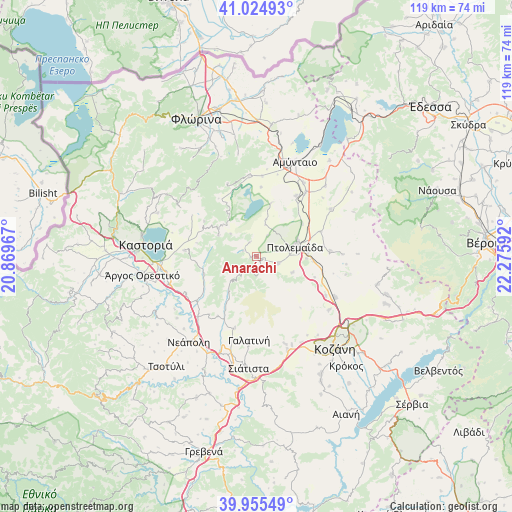
Anaráchi GPS coordinates[2]
40° 29' 32.424" North, 21° 34' 22.044" East
| Map corner | latitude | longitude |
|---|---|---|
| Upper-left | 41.02493°, | 20.86967° |
| Center: | 40.49234°, | 21.57279° |
| Lower-right: | 39.95549°, | 22.27592° |
| Map W x H: | 118.9×118.9 km | = 73.9×73.9mi |
| max Lat: | 41.72048° ⇑25.6% North |
| Anaráchi: | 40.49234° |
| min Lat: | ⇓74.4% South 34.8346° |
| min Long | Anaráchi | max Long |
| 19.40494° | 21.57279° | 29.59361° |
| W 18.3%⇐ | ⇒81.7% E |
Elevation
Elevation of Anaráchi is 715 m = 2346 ft, and this is 546.1 m = 1792 ft above average elevation for this country.
| Max E: |
1439 m = 4721 ft | 3.8% |
| Anaráchi | 715 m 2346 ft | |
| Avg. | 168.9 m = 554 ft | |
Min E: |
0 m = 0 ft | 96.2% |
See also: Greece elevation on elevation.city.
Geographical zone
Anaráchi is located in North temperate zone (between Tropic of Cancer and the Arctic Circle). Distance of this Northern Tropic circle is 1896.4 km =1178.4 mi to South.| Distance of | km | miles | from Anaráchi |
|---|---|---|---|
| North Pole | 5504.7 | 3420.5 | to North |
| Arctic Circle | 2898.8 | 1801.2 | to North |
| Tropic Cancer | 1896.4 | 1178.4 | to South |
| Equator | 4502.3 | 2797.6 | to South |


Nearby cities:
15 places around Anaráchi: (largest is in red/bold)
• Aetós
18.8 km =11.7 mi,  355°
355°
• Anatolikó
15.9 km =9.9 mi,  68°
68°
• Empório
1.3 km =0.8 mi,  252°
252°
• Erátyra
17.4 km =10.8 mi,  196°
196°
• Filótas
18.7 km =11.6 mi,  37°
37°
• Galatiní
19.3 km =12 mi,  185°
185°
• Gérmas
12.8 km =8 mi, 251°
• Korisós
16.6 km =10.3 mi,  274°
274°
• Levaía
20.3 km =12.6 mi,  32°
32°
• Léchovo
12.3 km =7.6 mi,  326°
326°
• Ptolemaḯda
9.3 km =5.8 mi, 74°
• Sklíthro
15.5 km =9.6 mi,  338°
338°
• Varikó
7.9 km =4.9 mi,  311°
311°
• Vogatsikó
18.5 km =11.5 mi,  241°
241°
• Árdassa
5.4 km =3.4 mi,  107°
107°
Sources, notices
• [Note1] Compared only with cities in Greece existing in our database
• [Src1] Map data: © OpenStreetMap contributors (CC-BY-SA)
• [Src2] Other city data from geonames.org with taken over terms of usage.
• [Src3] Geographical zone / Annual Mean Temperature by Robert A. Rohde @ Wikipedia
