Árdassa geodata
Árdassa (West Macedonia) is a populated place; located in Greece in Europe/Athens (GMT+3) time zone. With population of 934 people, there are 1087 cities with bigger population in this country. Compared to other cities in Greece, 73.6% of cities are located further ↓South; 80.2% of cities are located further →East and 93.7% of cities have lower elevation than Árdassa. Note1


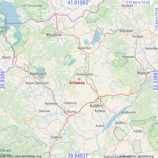
Árdassa GPS coordinates[2]
40° 28' 38.424" North, 21° 38' 0.672" East
| Map corner | latitude | longitude |
|---|---|---|
| Upper-left | 41.01005°, | 20.9304° |
| Center: | 40.47734°, | 21.63352° |
| Lower-right: | 39.94037°, | 22.33665° |
| Map W x H: | 118.9×118.9 km | = 73.9×73.9mi |
| max Lat: | 41.72048° ⇑26.4% North |
| Árdassa: | 40.47734° |
| min Lat: | ⇓73.6% South 34.8346° |
| min Long | Árdassa | max Long |
| 19.40494° | 21.63352° | 29.59361° |
| W 19.8%⇐ | ⇒80.2% E |
Elevation
Elevation of Árdassa is 626 m = 2054 ft, and this is 457.1 m = 1500 ft above average elevation for this country.
| Max E: |
1439 m = 4721 ft | 6.3% |
| Árdassa | 626 m 2054 ft | |
| Avg. | 168.9 m = 554 ft | |
Min E: |
0 m = 0 ft | 93.7% |
See also: Greece elevation on elevation.city.
Geographical zone
Árdassa is located in North temperate zone (between Tropic of Cancer and the Arctic Circle). Distance of this Northern Tropic circle is 1894.7 km =1177.3 mi to South.| Distance of | km | miles | from Árdassa |
|---|---|---|---|
| North Pole | 5506.4 | 3421.5 | to North |
| Arctic Circle | 2900.5 | 1802.3 | to North |
| Tropic Cancer | 1894.7 | 1177.3 | to South |
| Equator | 4500.7 | 2796.6 | to South |


Nearby cities:
15 places around Árdassa: (largest is in red/bold)
• Anaráchi
5.4 km =3.4 mi,  287°
287°
• Anatolikó
12.2 km =7.6 mi,  52°
52°
• Empório
6.5 km =4 mi,  281°
281°
• Erátyra
18.1 km =11.2 mi,  214°
214°
• Filótas
17.6 km =10.9 mi,  21°
21°
• Galatiní
18.9 km =11.7 mi,  201°
201°
• Gérmas
17.5 km =10.9 mi,  261°
261°
• Kleítos
19.7 km =12.2 mi,  105°
105°
• Komniná
17.5 km =10.9 mi,  43°
43°
• Koíla
21.1 km =13.1 mi,  140°
140°
• Levaía
19.6 km =12.2 mi, 17°
• Léchovo
16.9 km =10.5 mi,  314°
314°
• Ptolemaḯda
5.6 km =3.5 mi, 42°
• Sklíthro
19.4 km =12.1 mi,  325°
325°
• Varikó
13 km =8.1 mi,  302°
302°
Sources, notices
• [Note1] Compared only with cities in Greece existing in our database
• [Src1] Map data: © OpenStreetMap contributors (CC-BY-SA)
• [Src2] Other city data from geonames.org with taken over terms of usage.
• [Src3] Geographical zone / Annual Mean Temperature by Robert A. Rohde @ Wikipedia
