Polyplátanos geodata
Polyplátanos (Central Macedonia) is a populated place; located in Greece in Europe/Athens (GMT+3) time zone. With population of 892 people, there are 1139 cities with bigger population in this country. Compared to other cities in Greece, 80.7% of cities are located further ↓South; 67.7% of cities are located further →East and 76.9% of cities have higher elevation than Polyplátanos. Note1
Administrative division(s):
- Level 1: Central Macedonia
- Level 2: Nomós Imathías
- Level 3: Dimos Naousa


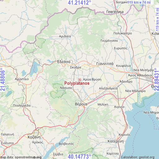
Polyplátanos GPS coordinates[2]
40° 40' 59.016" North, 22° 11' 28.248" East
| Map corner | latitude | longitude |
|---|---|---|
| Upper-left | 41.21412°, | 21.48806° |
| Center: | 40.68306°, | 22.19118° |
| Lower-right: | 40.14773°, | 22.89431° |
| Map W x H: | 118.6×118.6 km | = 73.7×73.7mi |
| max Lat: | 41.72048° ⇑19.3% North |
| Polyplátanos: | 40.68306° |
| min Lat: | ⇓80.7% South 34.8346° |
| min Long | Polyplátanos | max Long |
| 19.40494° | 22.19118° | 29.59361° |
| W 32.3%⇐ | ⇒67.7% E |
Elevation
Elevation of Polyplátanos is 21 m = 69 ft, and this is 147.9 m = 485 ft below average elevation for this country.
| Max E: |
1439 m = 4721 ft | 76.9% |
| Avg. | 168.9 m = 554 ft | |
| Polyplátanos | 21 m = 69 ft | |
Min E: |
0 m = 0 ft | 23.1% |
See also: Greece elevation on elevation.city.
Geographical zone
Polyplátanos is located in North temperate zone (between Tropic of Cancer and the Arctic Circle). Distance of this Northern Tropic circle is 1917.6 km =1191.5 mi to South.| Distance of | km | miles | from Polyplátanos |
|---|---|---|---|
| North Pole | 5483.5 | 3407.3 | to North |
| Arctic Circle | 2877.6 | 1788.1 | to North |
| Tropic Cancer | 1917.6 | 1191.5 | to South |
| Equator | 4523.5 | 2810.8 | to South |


Nearby cities:
15 places around Polyplátanos: (largest is in red/bold)
• Akrolímni
6.2 km =3.9 mi,  92°
92°
• Angelochóri
0.8 km =0.5 mi,  125°
125°
• Arsénio
4.4 km =2.7 mi,  322°
322°
• Charíessa
4.1 km =2.5 mi,  210°
210°
• Eirinoúpoli
0.6 km =0.4 mi,  166°
166°
• Episkopí
4.6 km =2.9 mi,  276°
276°
• Esóvalta
6.7 km =4.2 mi,  66°
66°
• Kopanós
7.6 km =4.7 mi,  223°
223°
• Lefkádia
6.9 km =4.3 mi,  241°
241°
• Monóspita
7.3 km =4.5 mi,  190°
190°
• Petraía
5.7 km =3.5 mi, 316°
• Rizó
7.2 km =4.5 mi, 320°
• Stavrodrómi
3.8 km =2.4 mi,  34°
34°
• Áno Zervochóri
3.6 km =2.2 mi,  144°
144°
• Áspro
6.2 km =3.9 mi,  19°
19°
Sources, notices
• [Note1] Compared only with cities in Greece existing in our database
• [Src1] Map data: © OpenStreetMap contributors (CC-BY-SA)
• [Src2] Other city data from geonames.org with taken over terms of usage.
• [Src3] Geographical zone / Annual Mean Temperature by Robert A. Rohde @ Wikipedia
