Kopanós geodata
Kopanós (Central Macedonia) is a populated place; located in Greece in Europe/Athens (GMT+3) time zone. With population of 2,202 people, there are 466 cities with bigger population in this country. Compared to other cities in Greece, 78.8% of cities are located further ↓South; 69.1% of cities are located further →East and 51.6% of cities have lower elevation than Kopanós. Note1
Administrative division(s):
- Level 1: Central Macedonia
- Level 2: Nomós Imathías
- Level 3: Dimos Naousa


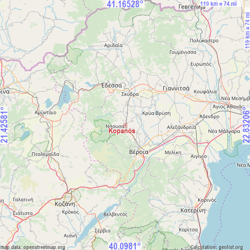
Kopanós GPS coordinates[2]
40° 38' 1.752" North, 22° 7' 44.148" East
| Map corner | latitude | longitude |
|---|---|---|
| Upper-left | 41.16528°, | 21.42581° |
| Center: | 40.63382°, | 22.12893° |
| Lower-right: | 40.0981°, | 22.83206° |
| Map W x H: | 118.7×118.7 km | = 73.8×73.8mi |
| max Lat: | 41.72048° ⇑21.2% North |
| Kopanós: | 40.63382° |
| min Lat: | ⇓78.8% South 34.8346° |
| min Long | Kopanós | max Long |
| 19.40494° | 22.12893° | 29.59361° |
| W 30.9%⇐ | ⇒69.1% E |
Elevation
Elevation of Kopanós is 87 m = 285 ft, and this is 81.9 m = 269 ft below average elevation for this country.
| Max E: |
1439 m = 4721 ft | 48.4% |
| Avg. | 168.9 m = 554 ft | |
| Kopanós | 87 m = 285 ft | |
Min E: |
0 m = 0 ft | 51.6% |
See also: Greece elevation on elevation.city.
Geographical zone
Kopanós is located in North temperate zone (between Tropic of Cancer and the Arctic Circle). Distance of this Northern Tropic circle is 1912.1 km =1188.1 mi to South.| Distance of | km | miles | from Kopanós |
|---|---|---|---|
| North Pole | 5489 | 3410.7 | to North |
| Arctic Circle | 2883.1 | 1791.5 | to North |
| Tropic Cancer | 1912.1 | 1188.1 | to South |
| Equator | 4518.1 | 2807.4 | to South |


Nearby cities:
15 places around Kopanós: (largest is in red/bold)
• Agía Marína
8.4 km =5.2 mi,  119°
119°
• Angelochóri
7.8 km =4.8 mi,  50°
50°
• Charíessa
3.7 km =2.3 mi,  58°
58°
• Eirinoúpoli
7.3 km =4.5 mi, 47°
• Episkopí
6 km =3.7 mi,  6°
6°
• Fyteía
8 km =5 mi,  191°
191°
• Lefkádia
2.3 km =1.4 mi,  338°
338°
• Marína
6.9 km =4.3 mi, 339°
• Monóspita
4.3 km =2.7 mi,  113°
113°
• Náousa
5.2 km =3.2 mi,  264°
264°
• Polyplátanos
7.6 km =4.7 mi,  43°
43°
• Stenímachos
3.4 km =2.1 mi,  184°
184°
• Trílofo
7.2 km =4.5 mi,  164°
164°
• Ágios Geórgios
6.5 km =4 mi, 122°
• Áno Zervochóri
7.7 km =4.8 mi,  71°
71°
Sources, notices
• [Note1] Compared only with cities in Greece existing in our database
• [Src1] Map data: © OpenStreetMap contributors (CC-BY-SA)
• [Src2] Other city data from geonames.org with taken over terms of usage.
• [Src3] Geographical zone / Annual Mean Temperature by Robert A. Rohde @ Wikipedia
