Lefkádia geodata
Lefkádia (Central Macedonia) is a populated place; located in Greece in Europe/Athens (GMT+3) time zone. With population of 914 people, there are 1113 cities with bigger population in this country. Compared to other cities in Greece, 79.5% of cities are located further ↓South; 69.4% of cities are located further →East and 50.3% of cities have higher elevation than Lefkádia. Note1
Administrative division(s):
- Level 1: Central Macedonia
- Level 2: Nomós Imathías
- Level 3: Dimos Naousa


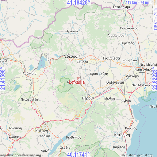
Lefkádia GPS coordinates[2]
40° 39' 10.728" North, 22° 7' 8.76" East
| Map corner | latitude | longitude |
|---|---|---|
| Upper-left | 41.18428°, | 21.41598° |
| Center: | 40.65298°, | 22.1191° |
| Lower-right: | 40.11741°, | 22.82223° |
| Map W x H: | 118.6×118.6 km | = 73.7×73.7mi |
| max Lat: | 41.72048° ⇑20.5% North |
| Lefkádia: | 40.65298° |
| min Lat: | ⇓79.5% South 34.8346° |
| min Long | Lefkádia | max Long |
| 19.40494° | 22.1191° | 29.59361° |
| W 30.6%⇐ | ⇒69.4% E |
Elevation
Elevation of Lefkádia is 80 m = 262 ft, and this is 88.9 m = 292 ft below average elevation for this country.
| Max E: |
1439 m = 4721 ft | 50.3% |
| Avg. | 168.9 m = 554 ft | |
| Lefkádia | 80 m = 262 ft | |
Min E: |
0 m = 0 ft | 49.7% |
See also: Greece elevation on elevation.city.
Geographical zone
Lefkádia is located in North temperate zone (between Tropic of Cancer and the Arctic Circle). Distance of this Northern Tropic circle is 1914.3 km =1189.5 mi to South.| Distance of | km | miles | from Lefkádia |
|---|---|---|---|
| North Pole | 5486.9 | 3409.4 | to North |
| Arctic Circle | 2881 | 1790.2 | to North |
| Tropic Cancer | 1914.3 | 1189.5 | to South |
| Equator | 4520.2 | 2808.7 | to South |


Nearby cities:
15 places around Lefkádia: (largest is in red/bold)
• Angelochóri
7.3 km =4.5 mi,  67°
67°
• Arsénio
7.6 km =4.7 mi,  26°
26°
• Charíessa
4 km =2.5 mi,  92°
92°
• Eirinoúpoli
6.8 km =4.2 mi, 65°
• Episkopí
4.1 km =2.5 mi,  20°
20°
• Kopanós
2.3 km =1.4 mi,  158°
158°
• Marína
4.6 km =2.9 mi,  340°
340°
• Monóspita
6.1 km =3.8 mi,  128°
128°
• Náousa
5 km =3.1 mi,  238°
238°
• Petraía
7.8 km =4.8 mi, 15°
• Polyplátanos
6.9 km =4.3 mi,  61°
61°
• Rizó
9.1 km =5.7 mi,  9°
9°
• Stenímachos
5.5 km =3.4 mi,  174°
174°
• Ágios Geórgios
8.5 km =5.3 mi, 131°
• Áno Zervochóri
8.2 km =5.1 mi, 87°
Sources, notices
• [Note1] Compared only with cities in Greece existing in our database
• [Src1] Map data: © OpenStreetMap contributors (CC-BY-SA)
• [Src2] Other city data from geonames.org with taken over terms of usage.
• [Src3] Geographical zone / Annual Mean Temperature by Robert A. Rohde @ Wikipedia
